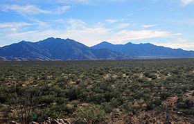
Santa Rita Mountains
| Santa Rita Mountains | |
|---|---|

View of the northern end of the Santa Ritas from the Santa Rita Experimental Range.
|
|
| Highest point | |
| Peak | Mount Wrightson |
| Elevation | 9,453 ft (2,881 m) |
| Coordinates | Coordinates: 31°43′23″N 110°52′49″W / 31.72306°N 110.88028°W |
| Geography | |
|
|
|
| Country | United States |
| State | Arizona |
| Region | Sonoran Desert |
| District | Tucson, AZ |
| Topo map | USGS Helvetia, AZ |
The Santa Rita Mountains (O'odham: To:wa Kuswo Doʼag), located about 65 km (40 mi) southeast of Tucson, Arizona, extend 42 km (26 mi) from north to south, then trending southeast. They merge again southeastwards into the Patagonia Mountains, trending northwest by southeast. The highest point in the range, and the highest point in the Tucson area, is Mount Wrightson, with an elevation of 9,453 feet (2,881 m), The range contains Madera Canyon, one of the world's premier birding areas. The Smithsonian Institution's Fred Lawrence Whipple Observatory is located on Mount Hopkins. The range is one of the Madrean sky islands.
The Santa Rita Mountains are mostly within the Coronado National Forest. Prior to 1908 they were the principal component of Santa Rita National Forest, which was combined with other small forest tracts to form Coronado. Much of the range is protected by the Mount Wrightson Wilderness. The Santa Rita Mountains were severely burned in July 2005 in the Florida Fire.
Other mountain ranges surrounding the Tucson valley include the Santa Catalina Mountains, the Rincon Mountains, the Tucson Mountains, and the Tortolita Mountains.
A large porphyry copper deposit has been identified near the old Helvetia mining district on the north flank of the range. The proposed Rosemont mine would be an open pit operation located in the Santa Ritas about two miles west of mile marker 44 on Arizona State Route 83.
...
Wikipedia

