Great St Bernard Tunnel

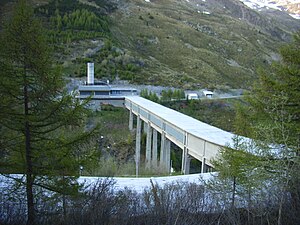
Italian side of the tunnel
|
|
| Overview | |
|---|---|
| Location |
|
| Coordinates | 45°51′52″N 7°10′22″E / 45.8645°N 7.17266°ECoordinates: 45°51′52″N 7°10′22″E / 45.8645°N 7.17266°E |
| Status | Active |
| Route |
E27 RN 27 |
| Start | Saint-Rhémy-en-Bosses |
| End | Bourg-Saint-Pierre |
| Operation | |
| Work begun | 1958 |
| Opened | 1964 |
| Toll |
16,40 € (A1) |
| Technical | |
| Length | 5,798 m (6,341 yd) |
| Highest elevation | 1918 |
| Lowest elevation | 1875 |
16,40 € (A1)
27,90 € (A2)
43,40 € (B1)
75,50 € (B2,B3)
110,00 € (3A,3B)
The Great St Bernard Tunnel (French: Tunnel du Grand Saint-Bernard), Italian: Traforo del Gran San Bernardo, German: Grosser-Sankt-Bernhard-Tunnel) is a road tunnel complementing the Great St Bernard Pass, linking Martigny (in the Swiss canton of Valais) with Saint-Rhémy-en-Bosses (in the Aosta Valley, in north western Italy).
There is a toll to use the tunnel, payable in full even for drivers who already display on their vehicles a . The tunnel comprises a section of the E27 route linking Belfort with Aosta.
For most of its 5,798-metre (6,341 yd) length the tunnel runs in a straight line, but incorporating a gentle slope. The northern end is 1,918 m (6,293 ft) above sea level while the southern end is only 1,875 m (6,152 ft) above sea level. At both ends, the approach road to the tunnel is covered by a gallery / avalanche shelter in order to minimize the risk of access to the tunnel being temporarily blocked during bad weather. Any frontier formalities are handled at the tunnel's north end, although the actual national frontier is 2,938 m (3,213 yd) from the Swiss tunnel entrance and 2,860 m (3,130 yd) from the Italian entrance.
The name of the tunnel comes directly from that of the Grand St Bernard Pass, and thereby indirectly from the saint who in AD 1049 founded the hospice high above the tunnel, that also bears his name. Tourists on the Swiss side additionally find themselves reminded by road side billboards of the saint's association with St Bernard dogs.
...
Wikipedia
