Gormley, Ontario
| Gormley | |
|---|---|
| Unincorporated community | |

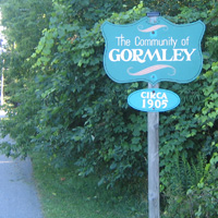
A sign found on Gormley Road East.
|
|
| Coordinates: 43°56′27″N 79°22′55″W / 43.94083°N 79.38194°W | |
| Country | Canada |
| Province | Ontario |
| Regional municipality | York Region |
| Town | Whitchurch–Stouffville, Richmond Hill |
| Amalgamation | (With Town of Stouffville) 1 January 1971 |
| Elevation | 257 m (843 ft) |
| Time zone | EST (UTC−5) |
| • Summer (DST) | EDT (UTC−4) |
| Forward sortation area | L0H, L4E |
| Area code(s) | 905 and 289 |
| NTS Map | 030M14 |
| GNBC Code | FBIOH |
Gormley is a hamlet in York Region, Ontario, Canada that overlaps parts of Richmond Hill, and Whitchurch–Stouffville, two municipalities within the Greater Toronto Area. It was divided into two parts due to the construction of Highway 404. A portion of Gormley situated within Richmond Hill's political boundaries is subject to "Heritage Conservation District" controls. A post office in Gormley (East) serves as the mailing address for the Whitchurch–Stouffville communities of Bethesda, Gormley, Preston Lake, Vandorf, and Wesley Corners.
Gormley Road East, on the south side of Stouffville Road, leads to Gormley Court and a dead-end at the railroad tracks. On the other side of the tracks, accessible by Leslie Street, is Gormley Road West. The community had a railway station until it was demolished in the early 1970s. Many of the houses are approximately 100 years old. The community celebrated its 100th anniversary in 2005.
The community was named after its first postmaster, James Gormley, who served from 1851 to 1876. The hamlet originally straddled the townships of Markham to the south and Whitchurch to the north, both in the County of York.
The old community of Gormley is situated east of the Highway 404 at the corner of Woodbine Avenue and Stouffville Road.
New Gormley or West Gormley, is the area near Leslie St and Stouffville Road.
A rail line owned by Canadian National Railway runs through West Gormley; it is CN's primary freight corridor connecting Greater Toronto to Northern Ontario and Western Canada. In 1907, a station was constructed in Gormley on Station Street, south of the original Stouffville Sideroad. The arrival of the railway was significant in the development of New Gormley, as a cluster of businesses that relied on the rail service grew up around the station. Houses of the owners and other related building contributed to further expansion of the community, which by the 1920s housed a general store, a blacksmith's shop, a garage, a planing mill, a grain elevator and feed mill, and a cement block and tile company. Many fine red-brick, two-storey homes were built along the main street. The station was important to local farmers who shipped milk and other produce from here to the city. The Gormley railway station was demolished in the early 1970s. Station Road, that once led to station, is now a narrow dead end street that gives access to a few homes and businesses from Gormley Road.
...
Wikipedia
