Gooding, Idaho
| Gooding, Idaho | |
|---|---|
| City | |

An aerial view of Gooding, Idaho, from the South. The road in the middle of the photo is Highway 46.
|
|
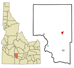
 Location in Gooding County and the state of Idaho |
|
| Location in the United States | |
| Coordinates: 42°56′14″N 114°42′49″W / 42.93722°N 114.71361°WCoordinates: 42°56′14″N 114°42′49″W / 42.93722°N 114.71361°W | |
| Country | United States |
| State | Idaho |
| County | Gooding |
| Established | 1907 |
| Incorporated | 1908 |
| Area | |
| • Total | 1.49 sq mi (3.86 km2) |
| • Land | 1.48 sq mi (3.83 km2) |
| • Water | 0.01 sq mi (0.03 km2) |
| Elevation | 3,573 ft (1,089 m) |
| Population (2010) | |
| • Total | 3,567 |
| • Estimate (2012) | 3,519 |
| • Density | 2,410.1/sq mi (930.5/km2) |
| Time zone | Mountain (UTC-7) |
| • Summer (DST) | Mountain (UTC-6) |
| ZIP code | 83330 |
| Area code(s) | 208 |
| FIPS code | 16-32140 |
| GNIS feature ID | 0399894 |
| Website | www.goodingidaho.org |
Gooding is the county seat and largest city of Gooding County, Idaho, United States. The population was 3,567 at the 2010 census.
The city is named for Frank R. Gooding, a local sheep rancher who became a prominent political figure in Idaho in the early 20th Century, serving as both Governor of Idaho and a United States Senator. The original name of Gooding was Toponis.
Gooding is home to the Idaho School for the Deaf and the Blind.
The world's largest factory for barrel cheese, the raw product for processed cheese, is located in Gooding. It has a capacity of 120,000 metric tons per year of barrel cheese and belongs to the Glanbia group. Gooding is also home to Gooding High School and Gooding Middle School.
Gooding is located at 42°56′14″N 114°42′49″W / 42.93722°N 114.71361°W (42.937097, -114.713480), near the confluence of the Big Wood River and Little Wood River, which merge to form the Malad River.
According to the United States Census Bureau, the city has a total area of 1.49 square miles (3.86 km2), of which, 1.48 square miles (3.83 km2) is land and 0.01 square miles (0.03 km2) is water.
...
Wikipedia

