Goleszów
| Goleszów | ||
|---|---|---|
| Village | ||

Village's centre
|
||
|
||
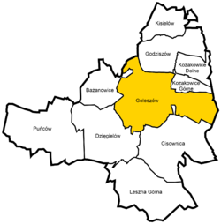
 Location of Goleszów within Gmina Goleszów |
||
| Location of Goleszów within Gmina Goleszów | ||
| Coordinates: 49°44′8.52″N 18°44′23.45″E / 49.7357000°N 18.7398472°E | ||
| Country | Poland | |
| Voivodeship | Silesian | |
| County | Cieszyn | |
| Gmina | Goleszów | |
| Sołectwo | Goleszów Dolny Goleszów Górny Goleszów Równia |
|
| First mentioned | 1223 | |
| Area | 12.11 km2 (4.68 sq mi) | |
| Population (2008) | 4,045 | |
| • Density | 330/km2 (870/sq mi) | |
| Time zone | CET (UTC+1) | |
| • Summer (DST) | CEST (UTC+2) | |
| Postal code | 43-440 | |
| Car plates | SCI | |
| Website | http://www.goleszow.pl | |
Goleszów [ɡɔˈlɛʂuf] (German: Golleschau) is a village and the seat of Gmina Goleszów (an administrative district) in Cieszyn County in Silesian Voivodeship, southern Poland. It has a population of about 4,000.
The name of the village is possessive in origin, derived from a personal name Golesz.
The village lies in the historical region of Cieszyn Silesia. It was first mentioned in a document of Bishop of Wrocław issued on 23 May 1223 for Norbertine Sisters in Rybnik among villages paying them a tithe, as Goles(u)ov(u)o. Politically it belonged then to the Duchy of Opole and Racibórz and the Castellany of Cieszyn, which was in 1290 formed in the process of feudal fragmentation of Poland into the Duchy of Teschen, ruled by a local branch of Silesian Piast dynasty. In 1327 the duchy became a fee of the Kingdom of Bohemia, which after 1526 became a part of the Habsburg Monarchy.
The village became a seat of a Catholic parish, according to a secondary source from the 19th century a stone church was already built in 1293. The parish was then mentioned in the register of Peter's Pence payment from 1447 among the 50 parishes of Teschen Deanery as Boleschaw.
...
Wikipedia


