Glenmont, Ohio
| Glenmont, Ohio | |
|---|---|
| Village | |

SS Peter and Paul Church
|
|
 Location of Glenmont, Ohio |
|
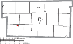
 Location of Glenmont in Holmes County |
|
| Coordinates: 40°31′10″N 82°5′43″W / 40.51944°N 82.09528°WCoordinates: 40°31′10″N 82°5′43″W / 40.51944°N 82.09528°W | |
| Country | United States |
| State | Ohio |
| County | Holmes |
| Township | Richland |
| Area | |
| • Total | 0.27 sq mi (0.70 km2) |
| • Land | 0.27 sq mi (0.70 km2) |
| • Water | 0 sq mi (0 km2) |
| Elevation | 879 ft (268 m) |
| Population (2010) | |
| • Total | 272 |
| • Estimate (2012) | 277 |
| • Density | 1,007.4/sq mi (389.0/km2) |
| Time zone | Eastern (EST) (UTC-5) |
| • Summer (DST) | EDT (UTC-4) |
| ZIP code | 44628 |
| Area code(s) | 330 |
| FIPS code | 39-30506 |
| GNIS feature ID | 1064731 |
Glenmont is a village in Holmes County, Ohio, United States. The population was 272 at the 2010 census.
In 1863 during the American Civil War, a riot by nearly 1,000 draft resisters in Glenmont was subdued by the Union Army in what became known as the Battle of Fort Fizzle.
Glenmont is located at 40°31′10″N 82°5′43″W / 40.51944°N 82.09528°W (40.519346, -82.095168).
According to the United States Census Bureau, the village has a total area of 0.27 square miles (0.70 km2), all land.
As of the census of 2010, there were 272 people, 116 households, and 67 families residing in the village. The population density was 1,007.4 inhabitants per square mile (389.0/km2). There were 123 housing units at an average density of 455.6 per square mile (175.9/km2). The racial makeup of the village was 98.2% White, 0.4% Native American, 0.7% Asian, 0.4% from other races, and 0.4% from two or more races. Hispanic or Latino of any race were 0.4% of the population.
...
Wikipedia
