Glaris
| Glarus | ||
|---|---|---|
 |
||
|
||
| Coordinates: 47°02′N 9°04′E / 47.033°N 9.067°ECoordinates: 47°02′N 9°04′E / 47.033°N 9.067°E | ||
| Country | Switzerland | |
| Canton | Glarus | |
| District | n.a. | |
| Area | ||
| • Total | 103.67 km2 (40.03 sq mi) | |
| Elevation (Stadtkirche Glarus) | 472 m (1,549 ft) | |
| Population (Dec 2016) | ||
| • Total | 12,515 | |
| • Density | 120/km2 (310/sq mi) | |
| Demonym(s) | German: Glarner(in) | |
| Postal code | 8750, 8754, 8755 | |
| SFOS number | 1632 | |
| Localities | Glarus, Netstal, Ennetbühls, Ennenda, Riedern, Hinter-Klöntal, Richisau, Klöntal | |
| Surrounded by | Glarus Nord, Glarus Süd, Muotathal (SZ), Innerthal (SZ) | |
| Twin towns | Wiesbaden-Biebrich (Germany) | |
| Website |
www SFSO statistics |
|
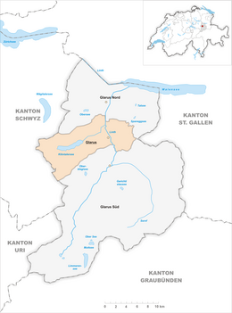
Glarus (German: [ˈɡlaːrʊs] (![]() listen); Alemannic German: Glaris; French: Glaris; Italian: Glarona; Romansh: Glaruna) is the capital of the canton of Glarus in Switzerland. Since 1 January 2011, the municipality Glarus incorporates the former municipalities of Ennenda, Netstal and Riedern.
listen); Alemannic German: Glaris; French: Glaris; Italian: Glarona; Romansh: Glaruna) is the capital of the canton of Glarus in Switzerland. Since 1 January 2011, the municipality Glarus incorporates the former municipalities of Ennenda, Netstal and Riedern.
Glarus lies on the river Linth between the foot of the Glärnisch (part of the Schwyzer Alps) to the west and the Schilt (Glarus Alps)to the east. Very few buildings built before the fire of 1861 remain. Wood, textile, and plastics, as well as printing, are the dominant industries. The symbol of the city is the neo-romanesque city church.
The official language of Glarus is (the Swiss variety of Standard) German, but the main spoken language is the local Alemannic Swiss German dialect.
...
Wikipedia


