Ennenda
| Ennenda | ||
|---|---|---|
| Former municipality of Switzerland | ||
 |
||
|
||
| Coordinates: 47°02′N 9°05′E / 47.033°N 9.083°ECoordinates: 47°02′N 9°05′E / 47.033°N 9.083°E | ||
| Country | Switzerland | |
| Canton | Glarus | |
| District | n.a. | |
| Area | ||
| • Total | 22.24 km2 (8.59 sq mi) | |
| Elevation | 478 m (1,568 ft) | |
| Population (December 2015) | ||
| • Total | 2,684 | |
| • Density | 120/km2 (310/sq mi) | |
| Postal code | 8755 | |
| SFOS number | 1607 | |
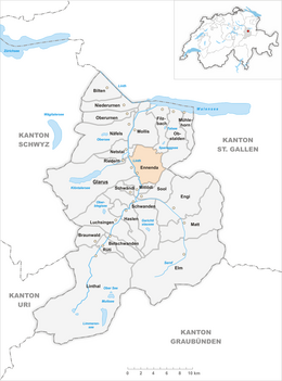
| Surrounded by | Filzbach, Glarus, Mitlödi, Mollis, Netstal, Obstalden, Sool | |
| Website |
www SFSO statistics |
|
Ennenda is a former municipality in the canton of Glarus in Switzerland. Effective from 1 January 2011, Ennenda is part of the municipality of Glarus.
Ennenda is first mentioned around 1303-07 as Obront-Ennant-A and Nydern-Ennant-A.
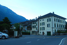
During the 19th century, Ennenda became a busy manufacturing village in the local textile industry, and retains some attractive villas and housing from that period.
Ennenda has an area, as of 2006[update], of 22.2 km2 (8.6 sq mi). Of this area, 35.5% is used for agricultural purposes, while 37.7% is forested. Of the rest of the land, 3.8% is settled (buildings or roads) and the remainder (23%) is non-productive (rivers, glaciers or mountains).
Ennenda is located on the right side of the Linth river, across from Glarus at the foot of the Schilt mountain. It consists of the village of Ennenda and the hamlets of Sturmigen, Ennetbühls and the mountain settlement of Ennetberge.
Ennenda had a population (as of 2010) of 2,684. As of 2007[update], 14.2% of the population was made up of foreign nationals. Over the last 10 years the population has decreased at a rate of -9.6%. Most of the population (as of 2000[update]) speaks German (87.6%), with Italian being second most common ( 3.7%) and Albanian being third ( 2.8%).
In the 2007 federal election the most popular party was the SPS which received 58.8% of the vote. Most of the rest of the votes went to the SVP with 34.5% of the vote.
...
Wikipedia


