Gisors
| Gisors | ||
|---|---|---|

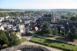
City as seen from the castle terrasse
|
||
|
||
| Coordinates: 49°16′52″N 1°46′38″E / 49.2811°N 1.7772°ECoordinates: 49°16′52″N 1°46′38″E / 49.2811°N 1.7772°E | ||
| Country | France | |
| Region | Normandy | |
| Department | Eure | |
| Arrondissement | Les Andelys | |
| Canton | Gisors | |
| Intercommunality | Gisors-Epte-Lévrière | |
| Government | ||
| • Mayor (2008–2014) | Marcel Larmanou | |
| Area1 | 16.67 km2 (6.44 sq mi) | |
| Population (2008)2 | 11,681 | |
| • Density | 700/km2 (1,800/sq mi) | |
| Time zone | CET (UTC+1) | |
| • Summer (DST) | CEST (UTC+2) | |
| INSEE/Postal code | 27284 / 27140 | |
| Elevation | 47–142 m (154–466 ft) (avg. 74 m or 243 ft) |
|
|
1 French Land Register data, which excludes lakes, ponds, glaciers > 1 km² (0.386 sq mi or 247 acres) and river estuaries. 2Population without double counting: residents of multiple communes (e.g., students and military personnel) only counted once. |
||
1 French Land Register data, which excludes lakes, ponds, glaciers > 1 km² (0.386 sq mi or 247 acres) and river estuaries.
Gisors is a commune of Normandy, France. It is located 62.9 km (39.1 mi) northwest from the centre of Paris.
Gisors, together with the neighbouring communes of Trie-Château and Trie-la-Ville, form an urban area of 12,669 inhabitants (1999 census). This urban area is a satellite town of Paris.
Gisors is located in the Vexin normand region of Normandy at the confluence of the Epte, Troesne and Réveillon rivers .
The Gisors-Embranchement station is the terminus of a Transilien suburban rail service from the Paris Saint-Lazare station.
Motte and Castle
Castle of Gisors
The so-called Grosse Tour ("Big Tower") of the St-Gervais-St-Protais church was built between 1542 and 1590.
...
Wikipedia


