Gimry
| Gimry (English) Гимры (Russian) Генуб (Avar) |
|
|---|---|
| - Rural locality - Selo |
|
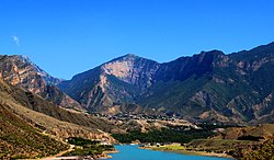
 View of Gimry |
|
 Location of the Republic of Dagestan in Russia |
|
|
|
|
|
|
|
|
|
|
| Administrative status | |
| Country | Russia |
| Federal subject | Republic of Dagestan |
| Administrative district | Untsukulsky District |
| Statistics | |
| Population (2010 Census) | 4,654 inhabitants |
| Time zone | MSK (UTC+03:00) |
| Postal code(s) | 368951 |
| Dialing code(s) | +7 87257 |
| on | |
Gimry (Russian: Гимры) is a rural locality (a selo) in Untsukulsky District of the Republic of Dagestan, Russia, located in the mountain where Imam Shamil, the third Imam of Dagestan, was born. Population: 4,654 (2010 Census);3,362 (2002 Census).
Gimry is located on the east bank of the north-flowing Avar Koysu river at the bottom of a 5000-foot deep canyon. On the east side the upper 1500 feet are nearly vertical. It is at the mouth of a side canyon that extends about 7 kilometers southeast. In the nineteenth century the only approaches from the east were from the village of Karanai and along the sides of the Sulak and Avar Koysu canyons or by a path down to the side canyon where the Gimry tunnel is now. Four kilometers north the Avar Koysu joins the east-flowing Andi Koysu to form the Sulak River. To the south on the Avar Koysu is the village of Untsokul, the Irganay dam and the villages of Irganay and Zirani. West on the Andi Koysu are the rock fortress of Akhulgo and the villages of Ashitla and Igali.
Gimry was part of a group of villages called or Koysubu or Hindal. It was a center of resistance to Russia during the Murid War (1829-1859). Both Kazi Mulla and Imam Shamil were born here in the 1790s. In 1830, Baron Rosen tried to attack it and gave up. In 1832, Kazi Mulla died here during the Battle of Gimry. In 1834, Lanskoy attacked it. In 1837, the Russians were defeated just to the north at the battle of the Ashitla bridge. Later in the same year the village of Ashitla to the west was destroyed. In 1839 it was neutral during the Siege of Akhoulgo. In 1840, Klugenau attacked it. After 1840, the center of resistance moved northwest to the forests of Chechnya. During the Dagestan Uprising (1920) ninety percent of the buildings were destroyed by artillery. Its surrender in late February 1921 was almost the end of the uprising.
...
Wikipedia


