Gier River
| Gier | |
|---|---|

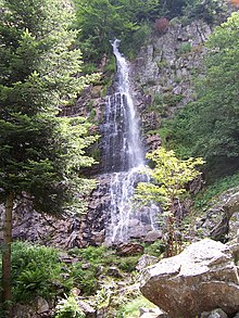
Le saut du Gier waterfalls
|
|
| Country | France |
| Region | Rhône-Alpes |
| Basin features | |
| Main source |
Mont Pilat 1,300 m (4,300 ft) |
| River mouth |
Givors 145 m (476 ft) |
| Progression | Rhône→ Mediterranean Sea |
| River system | Rhône |
| Basin size | 417 km2 (161 sq mi) |
| Physical characteristics | |
| Length | 40.3 km (25.0 mi) |
| Discharge |
|
Coordinates: 45°35′13″N 4°46′27″E / 45.586846°N 4.774071°E
The Gier is a French river that flows in a northeast direction through the Loire and Rhône departments. It is a tributary of the Rhône, which it enters from the right bank. The Gier valley was formerly heavily industrialized with coal and iron mines and factories.
The word "Gier" derives from the Latin Jaresis, which also gave rise to the name côté Jarez for the north side of the valley of the Gier, and is included in the names of several municipalities: Sainte-Croix-en-Jarez, Saint-Paul-en-Jarez, Saint-Romain-en-Jarez, La Tour-en-Jarez, Saint-Christo-en-Jarez, Rive-de-Gier and Saint-Romain-en-Gier.
The Gier rises at La Jasserie on the Perdrix mountain at about 1,300 metres (4,300 ft) in the Pilat massif. The "Saut du Gier" waterfall near the head of the river is in the Pilat Regional Natural Park. The river runs for 40.3 kilometres (25.0 mi) before joining the Rhone at Givors. The Gier receives the Janon from its left at Saint-Chamond. The Janon from Terrenoire (now part of Saint-Étienne) to Saint-Chamond, and then the Gier from Saint-Chamond to Givors, create a valley in the coal basin between the Pilat massif to the south and the Riverie chain of the Monts du Lyonnais to the north.
...
Wikipedia
