Gibbstown, New Jersey
| Gibbstown, New Jersey | |
|---|---|
| Census-designated place | |

|
|
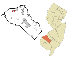
 Map of Gibbstown highlighted within Gloucester County. Right: Location of Gloucester County in New Jersey. |
|
| Coordinates: 39°49′28″N 75°16′41″W / 39.82454°N 75.278082°WCoordinates: 39°49′28″N 75°16′41″W / 39.82454°N 75.278082°W | |
| Country |
|
| State |
|
| County | Gloucester |
| Township | Greenwich |
| Area | |
| • Total | 1.642 sq mi (4.253 km2) |
| • Land | 1.642 sq mi (4.253 km2) |
| • Water | 0.000 sq mi (0.000 km2) 0.00% |
| Elevation | 13 ft (4 m) |
| Population (2010 Census) | |
| • Total | 3,739 |
| • Density | 2,277.0/sq mi (879.2/km2) |
| Time zone | Eastern (EST) (UTC-5) |
| • Summer (DST) | EDT (UTC-4) |
| ZIP code | 08027 |
| Area code(s) | 856 |
| FIPS code | 3426100 |
| GNIS feature ID | 02389839 |
Gibbstown is a unincorporated community and census-designated place (CDP) located within Greenwich Township, in Gloucester County, New Jersey, United States. As of the 2010 United States Census, the CDP's population was 3,739. Gibbstown is the location of C. A. Nothnagle Log House, purportedly the oldest house in New Jersey and the oldest surviving log house in the U.S., dating to around 1638.
According to the United States Census Bureau, Gibbstown had a total area of 1.642 square miles (4.253 km2), all of which was land.
The Port of Paulsboro is located on the Delaware River and Mantua Creek in and around Paulsboro. Traditionally one of the nation's busiest for marine transfer operations of petroleum products, including the Paulsboro Refinery, which is mostly located in Gibbstown. The port is being redeveloped as an adaptable omniport able to handle a diversity of bulk, break bulk cargo and shipping containers. Studies completed in 2012 concluded that the port is well suited to become a center for the manufacture, assembly, and transport of wind turbines and platforms the development of Atlantic Wind Connection
As of the 2010 United States Census, there were 3,739 people, 1,472 households, and 1,039 families residing in the CDP. The population density was 2,277.0 per square mile (879.2/km2). There were 1,551 housing units at an average density of 944.5 per square mile (364.7/km2). The racial makeup of the CDP was 95.91% (3,586) White, 1.77% (66) Black or African American, 0.05% (2) Native American, 0.43% (16) Asian, 0.00% (0) Pacific Islander, 0.32% (12) from other races, and 1.52% (57) from two or more races. Hispanic or Latino of any race were 2.01% (75) of the population.
...
Wikipedia
