Giannutri

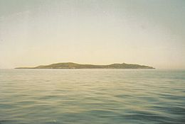
Giannutri island from sea
|
|
 |
|
| Geography | |
|---|---|
| Location | Tyrrhenian Sea |
| Archipelago | Tuscan Archipelago |
| Total islands | 1 |
| Area | 2.6 km2 (1.0 sq mi) |
| Length | 2.8 km (1.74 mi) |
| Width | 0.5 km (0.31 mi) |
| Highest elevation | 88 m (289 ft) |
| Highest point | Poggio del Capel Rosso |
| Administration | |
|
Italy
|
|
| Region | Tuscany |
| Province | Grosseto (GR) |
| Comune | Isola del Giglio |
| Demographics | |
| Population | 27 registered resident population (2011) |

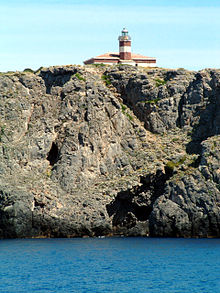
Giannutri Lighthouse
|
|
|
Tuscany
|
|
| Location |
Grosseto Tuscany Italy |
|---|---|
| Coordinates | 42°14′22.1″N 11°06′28.8″E / 42.239472°N 11.108000°E |
| Year first constructed | 1883 |
| Automated | yes |
| Construction | concrete and brick |
| Tower shape | cylindrical tower with lantern and gallery |
| Markings / pattern | tower attached to the front of one-story keeper’s house white and red painted band |
| Height | 26 feet (7.9 m) |
| Focal height | 200 feet (61 m) |
| Light source | solar power |
| Range | 13 nautical miles (24 km; 15 mi) |
| Characteristic | Fl W 5s. |
| Fog signal | no |
| Admiralty number | E1496 |
| NGA number | 9108 |
| ARLHS number | ITA-209 |
| Italy number | 2184 E.F |
| Managing agent | Marina Militare |
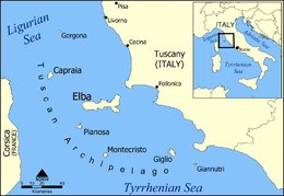
Giannutri (Italian pronunciation: [dʒanˈnuːtri]) is a small island in the Tyrrhenian Sea off the coast of Tuscany, Italy; it is the southernmost island of the Tuscan Archipelago and it is a frazione of the comune of Isola del Giglio in the Province of Grosseto.
Giannutri was known as Dianium by the Romans and Artemisia, Αρτεμησία by the Greeks; it has a crescent moon shape which forms the Gulf of Spalmatoio and is placed at 16 kilometres (9.9 mi) south east from the Isola del Giglio and 17.6 kilometres (10.9 mi) from Porto Ercole. The island has a coastal perimeter of 11 km (7 mi), is stretched approximately 2.8 km (2 mi) from Punta del Capo Rosso to Punta Secca (north-south) and 2 km (1 mi) from Punta San Francesco to Punta della Salvezza (west-east). The soil is calcareous and has a rocky and rugged coasts with inlets and caves mainly in the southern part interrupted only by two beaches called Cala dello Spalmatoio (on the north-east) and Cala Maestra (on the north-west) where are the dockings. The island landscape has three hills: Poggio del Cannone (83 m) and Monte Mario (78 m) in the northern part and Poggio Capel Rosso (93 m), the highest, in the southern where is the lighthouse.
The island’s flora is prevalently a high macchia mediterranea in the northern part which become garrigue in the southern. Plants as arbutus, Myrtus, pistacia lentiscus, mock privet, Mediterranean buckthorn, juniperus phoenicea and limonium sommierianum knew only on Isola del Giglio and Montecristo, grow up on the island. The mild climate has favoured the growth of plants such as euphorbia, palm trees and wild orchids. The marine flora is abundant in sponges, madreporaria, black coral and red coral.
...
Wikipedia

