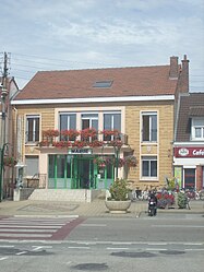
Ghyvelde
|
Ghyvelde Gijvelde |
||
|---|---|---|

Ghyvelde in the arrondissement of Dunkirk
|
||
|
||
| Coordinates: 51°03′08″N 2°31′41″E / 51.0522°N 2.5281°ECoordinates: 51°03′08″N 2°31′41″E / 51.0522°N 2.5281°E | ||
| Country | France | |
| Region | Hauts-de-France | |
| Department | Nord | |
| Arrondissement | Dunkirk | |
| Canton | Dunkerque-2 | |
| Intercommunality | Flandre | |
| Government | ||
| • Mayor (2016–2020) | Jean Decool | |
| Area1 | 35.92 km2 (13.87 sq mi) | |
| Population (2013)2 | 4,130 | |
| • Density | 110/km2 (300/sq mi) | |
| Time zone | CET (UTC+1) | |
| • Summer (DST) | CEST (UTC+2) | |
| INSEE/Postal code | 59260 /59254 | |
| Elevation | 0–25 m (0–82 ft) (avg. 4 m or 13 ft) |
|
|
1 French Land Register data, which excludes lakes, ponds, glaciers > 1 km² (0.386 sq mi or 247 acres) and river estuaries. 2Population without double counting: residents of multiple communes (e.g., students and military personnel) only counted once. |
||
1 French Land Register data, which excludes lakes, ponds, glaciers > 1 km² (0.386 sq mi or 247 acres) and river estuaries.
Ghyvelde (Dutch: Gijvelde) is a commune in the Nord department in northern France. It is located on the Belgian border, and just inland from the North Sea. It is, after Bray-Dunes, the second most northern commune of France. The E40/A16 passes through the commune. On 1 January 2016, the former commune Les Moëres was merged into Ghyvelde.
Town hall
Saint-Vincent church
Ermine, on a bend gules, 3 escallops bendwise Or. (Ghyvelde and Hondschoote use the same arms.)
...
Wikipedia


