Gers
| Gers | |||
|---|---|---|---|
| Department | |||

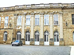
Prefecture building of the Gers department, in Auch
|
|||
|
|||
 Location of the Gers in France |
|||
| Coordinates: 43°39′N 0°35′E / 43.650°N 0.583°ECoordinates: 43°39′N 0°35′E / 43.650°N 0.583°E | |||
| Country | France | ||
| Region | Occitanie | ||
| Prefecture | Auch | ||
| Subprefectures |
Condom Mirande |
||
| Government | |||
| • President of the General Council | Jean-Pierre Pujol (PS) | ||
| Area | |||
| • Total | 6,257 km2 (2,416 sq mi) | ||
| Population (2013) | |||
| • Total | 190,276 | ||
| • Rank | 90th | ||
| • Density | 30/km2 (79/sq mi) | ||
| Time zone | CET (UTC+1) | ||
| • Summer (DST) | CEST (UTC+2) | ||
| Department number | 32 | ||
| Arrondissements | 3 | ||
| Cantons | 17 | ||
| Communes | 462 | ||
| ^1 French Land Register data, which exclude estuaries, and lakes, ponds, and glaciers larger than 1 km2 | |||
The Gers (French: le Gers, pronounced: [ʒɛʁs] or [ʒɛʁ]; Gascon: Gers) is a department in the Occitanie region in the southwest of France named after the Gers River.
Inhabitants are called les Gersois.
In the Middle Ages, the Lordship of L'Isle-Jourdain was nearby.
The Gers is one of the original 83 departments created during the French Revolution on 4 March 1790. It was created from parts of the former provinces of Guyenne and Gascony.
In 1808 it lost Lavit on its north-eastern side to the newly created department of Tarn-et-Garonne.
The culture is largely agricultural, with great emphasis on the local gastronomical specialties such as:
Also, some prominent cultivated crops are corn, colza, sunflowers and grain.
The Gascon language is a dialect of Occitan, but it is not widely spoken. The department is characterised by sleepy bastide villages and rolling hills with the Pyrenees visible to the south.
...
Wikipedia


