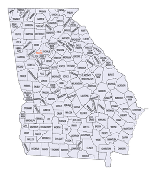
Georgia counties
| Counties of Georgia | |
|---|---|
 |
|
| Location | State of Georgia |
| Number | 159 |
| Populations | 1,680 (Taliaferro) – 1,010,562 (Fulton) |
| Areas | 121 square miles (310 km2) (Clarke) – 903 square miles (2,340 km2) (Ware) |
| Government | County government |
| Subdivisions | Cities, towns, unincorporated communities, census designated place |
The U.S. State of Georgia is divided into 159 counties, more than any other state except for Texas, which has 254 counties. Under the Georgia State Constitution, all of its counties are granted home rule to deal with problems that are purely local in nature. Also, eight consolidated city-counties have been established in Georgia: Athens–Clarke County, Augusta–Richmond County, Columbus–Muscogee County, Georgetown–Quitman County, Statenville–Echols County,Macon–Bibb County, Cusseta–Chattahoochee County, and Preston-Webster County.
From 1732 until 1758, the minor civil divisions were districts and towns. In 1758, the Province of Georgia was divided into eight parishes, and another four parishes were partitioned in 1765; in 1777, the original eight counties of the state were created. These were Burke, Camden, Chatham, Effingham, Glynn, Liberty, Richmond and Wilkes, all created on February 5, 1777.
...
Wikipedia
