Preston, Georgia
| Preston, Georgia | |
|---|---|
| Unincorporated community | |

Preston City Hall
|
|
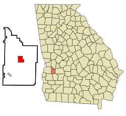
 Location in Webster County and the state of Georgia |
|
| Coordinates: 32°3′39″N 84°32′18″W / 32.06083°N 84.53833°WCoordinates: 32°3′39″N 84°32′18″W / 32.06083°N 84.53833°W | |
| Country | United States |
| State | Georgia |
| County | Webster |
| Area | |
| • Total | 4.5 sq mi (11.7 km2) |
| • Land | 4.5 sq mi (11.7 km2) |
| • Water | 0 sq mi (0 km2) |
| Elevation | 459 ft (140 m) |
| Population (2000) | |
| • Total | 453 |
| • Density | 100.7/sq mi (38.7/km2) |
| Time zone | Eastern (EST) (UTC-5) |
| • Summer (DST) | EDT (UTC-4) |
| ZIP code | 31824 |
| Area code(s) | 229 |
| FIPS code | 13-62720 |
| GNIS feature ID | 0332757 |
Preston is an unincorporated community in Webster County, Georgia, United States. The population was 453 at the 2000 census. From 1857 to 2009, Preston was an incorporated municipality. The community is the county seat of Webster County.
Preston was founded in 1856 as the seat of Webster County. It was incorporated as a town in 1857 and as a city in 1977. In 2009, the city was disincorporated and consolidated with the Unified Government of Webster County.
Preston is located at 32°3′39″N 84°32′18″W / 32.06083°N 84.53833°W (32.060789, -84.538287).
According to the United States Census Bureau, the town has a total area of 4.5 square miles (12 km2), all of it land.
As of the census of 2000, there were 453 people, 190 households, and 129 families residing in the town. The population density was 100.1 people per square mile (38.6/km²). There were 205 housing units at an average density of 45.3 per square mile (17.5/km²). The racial makeup of the town was 67.77% White, 28.26% African American, 0.22% Native American, 3.53% from other races, and 0.22% from two or more races. Hispanic or Latino of any race were 3.75% of the population.
...
Wikipedia
