Georgia Highway 400
| State Route 400 | ||||
|---|---|---|---|---|

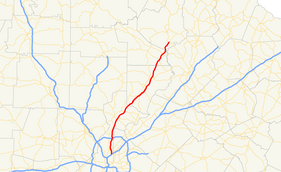
Map of northern Georgia with SR 400 highlighted in red
|
||||
| Route information | ||||
| Maintained by GDOT | ||||
| Length: | 53.70 mi (86.42 km) | |||
| Existed: | 1971, 1993 – present | |||
| Major junctions | ||||
| South end: |
|
|||
|
|
||||
| North end: |
|
|||
| Location | ||||
| Counties: | Fulton, Forsyth, Dawson, Lumpkin | |||
| Highway system | ||||
|
||||
![]()
![]() I‑285 / US 19 in Sandy Springs
I‑285 / US 19 in Sandy Springs![]() SR 20 in Cumming
SR 20 in Cumming![]() SR 369 in Cumming
SR 369 in Cumming
Georgia state route 400 (officially "SR 400", nearly always Georgia 400 to the public) is a controlled-access state highway in the northern part of the U.S. state of Georgia. It is concurrent with U.S. Route 19 (US 19) from exit 4 (Interstate 285) until its terminus south-southeast of Dahlonega, linking the city of Atlanta to its north-central suburbs and exurbs. Georgia 400 travels from the Lindbergh neighborhood in the Buckhead district of Atlanta, at Interstate 85 (I-85), to just south-southeast of Dahlonega. Like the Interstate highways, it is a limited-access road (with interchanges instead of intersections), but unlike the interstates (which were renumbered by GDOT in 2000), the exit numbers are not mileage-based, they are sequential. Once Georgia 400 passes exit 17 (Georgia 306), it changes from a limited-access freeway into an at-grade divided highway with traffic lights, but still with a high speed limit of 65 miles per hour (105 km/h), and ends at the J.B. Jones Intersection at Georgia 60/Georgia 115 in Lumpkin County.
...
Wikipedia

