Georgetown, SC
| Georgetown, South Carolina | |
|---|---|
| City | |

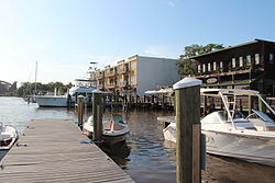
Georgetown harbor
|
|
 Location in Georgetown County and the state of South Carolina. |
|
| Coordinates: 33°22′3″N 79°17′38″W / 33.36750°N 79.29389°WCoordinates: 33°22′3″N 79°17′38″W / 33.36750°N 79.29389°W | |
| Country | United States |
| State | South Carolina |
| County | Georgetown |
| Incorporated (town) | 1938 |
| Incorporated (city) | 1957 |
| Government | |
| • Mayor | Jack Miller Scoville, Jr. |
| Area | |
| • Total | 7.5 sq mi (19.5 km2) |
| • Land | 6.9 sq mi (17.9 km2) |
| • Water | 0.6 sq mi (1.6 km2) |
| Elevation | 18 ft (5 m) |
| Population (2010) | |
| • Total | 9,163 |
| • Density | 1,326/sq mi (512.0/km2) |
| Time zone | EST (UTC-5) |
| • Summer (DST) | EDT (UTC-4) |
| ZIP codes | 29440, 29442 |
| Area code(s) | 843 |
| FIPS code | 45-28870 |
| GNIS feature ID | 1247888 |
| Website | www |
Georgetown is the third oldest city in the U.S. state of South Carolina and the county seat of Georgetown County, in the Lowcountry. As of the 2010 census it had a population of 9,163. Located on Winyah Bay at the confluence of the Black, Great Pee Dee, Waccamaw, and Sampit rivers, Georgetown is the second largest seaport in South Carolina, handling over 960,000 tons of materials a year.
Georgetown is located at 33°22′3″N 79°17′38″W / 33.36750°N 79.29389°W (33.367434, -79.293807).
According to the United States Census Bureau, the city has a total area of 7.5 square miles (19.5 km2), of which 6.9 square miles (17.9 km2) are land and 0.62 square miles (1.6 km2), or 8.06%, is water.
Winyah Bay was formed from a submergent or drowned coastline. The original rivers had a lower baseline, but either the ocean rose or the land sank, flooding the river valleys and making a good location for a harbor. The rising of the ocean may have been due to melting of glacial ice at the end of the ice age.
...
Wikipedia
