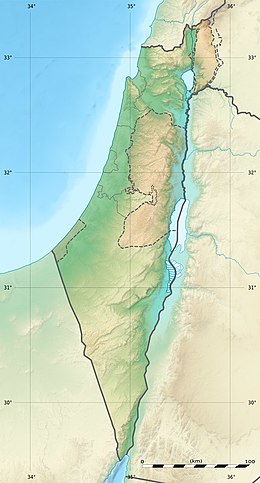
Geography of Israel
 |
|
| Continent | Asia |
|---|---|
| Region | Levant |
| Coordinates | 31°N 35°E / 31°N 35°ECoordinates: 31°N 35°E / 31°N 35°E |
| Area | Ranked 147th |
| • Total | 20,770 km2 (8,020 sq mi) |
| • Land | 97.88% |
| • Water | 2.12% |
| Coastline | 273 km (170 mi) |
| Borders | |
| Highest point | Mount Meron |
| Lowest point | Dead Sea |
| Longest river | Jordan River |
| Largest lake | Sea of Galilee |
| Climate | Mediterranean |
| Natural Resources | Offshore gas fields, Dead Sea minerals (potash, magnesium) |
| Tel Aviv | ||||||||||||||||||||||||||||||||||||||||||||||||||||||||||||
|---|---|---|---|---|---|---|---|---|---|---|---|---|---|---|---|---|---|---|---|---|---|---|---|---|---|---|---|---|---|---|---|---|---|---|---|---|---|---|---|---|---|---|---|---|---|---|---|---|---|---|---|---|---|---|---|---|---|---|---|---|
| Climate chart () | ||||||||||||||||||||||||||||||||||||||||||||||||||||||||||||
|
||||||||||||||||||||||||||||||||||||||||||||||||||||||||||||
|
||||||||||||||||||||||||||||||||||||||||||||||||||||||||||||
| J | F | M | A | M | J | J | A | S | O | N | D |
|
127
17
9
|
90
18
10
|
61
19
12
|
18
23
14
|
2.6
25
17
|
0
28
21
|
0
29
23
|
0
30
24
|
0.4
29
23
|
26
27
19
|
79
23
15
|
126
19
11
|
| Average max. and min. temperatures in °C | |||||||||||
| Precipitation totals in mm | |||||||||||
| Source: Israel Meteorological Service | |||||||||||
| Imperial conversion | |||||||||||
|---|---|---|---|---|---|---|---|---|---|---|---|
| J | F | M | A | M | J | J | A | S | O | N | D |
|
5
63
48
|
3.5
64
50
|
2.4
67
53
|
0.7
73
58
|
0.1
77
63
|
0
82
69
|
0
85
73
|
0
86
75
|
0
85
73
|
1
81
66
|
3.1
74
58
|
5
67
52
|
| Average max. and min. temperatures in °F | |||||||||||
| Precipitation totals in inches | |||||||||||
| Beit Dagan | ||||||||||||||
|---|---|---|---|---|---|---|---|---|---|---|---|---|---|---|
| Climate chart () | ||||||||||||||
|
