Gennevilliers
| Gennevilliers | ||
|---|---|---|

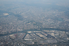
An aerial view of the Port of Gennevilliers
|
||
|
||
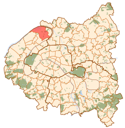
 Paris and inner ring départements |
||
| Coordinates: 48°56′00″N 2°18′00″E / 48.9333°N 2.3000°ECoordinates: 48°56′00″N 2°18′00″E / 48.9333°N 2.3000°E | ||
| Country | France | |
| Region | Île-de-France | |
| Department | Hauts-de-Seine | |
| Arrondissement | Nanterre | |
| Canton | Chef-lieu of 2 cantons (Gennevilliers-Nord et Sud) | |
| Government | ||
| • Mayor (2008-2014) | Jacques Bourgoin | |
| Area1 | 11.64 km2 (4.49 sq mi) | |
| Population (2009)2 | 41,689 | |
| • Density | 3,600/km2 (9,300/sq mi) | |
| Time zone | CET (UTC+1) | |
| • Summer (DST) | CEST (UTC+2) | |
| INSEE/Postal code | 92036 / 92230 | |
| Elevation | 21–33 m (69–108 ft) | |
|
1 French Land Register data, which excludes lakes, ponds, glaciers > 1 km² (0.386 sq mi or 247 acres) and river estuaries. 2Population without double counting: residents of multiple communes (e.g., students and military personnel) only counted once. |
||
1 French Land Register data, which excludes lakes, ponds, glaciers > 1 km² (0.386 sq mi or 247 acres) and river estuaries.
Gennevilliers (French pronunciation: [ʒənvilje]) is a commune in the northwestern suburbs of Paris, in the Hauts-de-Seine département of France. It is located 9.1 km (5.7 mi) from the center of Paris.
On 9 April 1929, one-fifth of the territory of Gennevilliers was detached and became the commune of Villeneuve-la-Garenne.
Gennevilliers is the site of the main river port Port of Gennevilliers of Paris on the Seine river.
Gennevilliers is served by three stations on Paris Métro line 13: Les Courtilles, Les Agnettes and Gabriel Péri. All three are at the border with the commune of Asnières-sur-Seine.
Gennevilliers is also served by two stations on Paris RER line C: Les Grésillons and Gennevilliers.
Schools include:
There is a senior high school, Lycée Galilée.
Gennevilliers is twinned with:
...
Wikipedia

