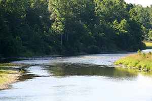
Genesee River
| Genesee River (Čunehstí•yu•) | |
| River | |
|
Genesee River near Belmont
|
|
| Country | United States |
|---|---|
| States | New York, Pennsylvania |
|
Counties & Tributaries |
(see Navbox, below) |
| City | Rochester, NY |
| Source | |
| - location | Ulysses Township, Potter County, Pennsylvania |
| - elevation | 2,240 ft (683 m) |
| - coordinates | 41°54′12″N 77°43′58″W / 41.90333°N 77.73278°W |
| Secondary source | Eastern Triple Divide |
| - location | near Gold, Potter County, Pennsylvania |
| - elevation | 2,320 ft (707 m) |
| - coordinates | 41°51′20.5″N 77°49′48.4″W / 41.855694°N 77.830111°W |
| Mouth | Lake Ontario |
| - location | Charlotte, Rochester, Monroe County, New York |
| - elevation | 256 ft (78 m) |
| - coordinates | 43°15′31″N 77°36′10″W / 43.25861°N 77.60278°WCoordinates: 43°15′31″N 77°36′10″W / 43.25861°N 77.60278°W |
| Length | 157 mi (253 km) |
| Basin | 2,500 sq mi (6,475 km2) |
| Discharge | for Lake Ontario |
| - average | 4,430 cu ft/s (125 m3/s) |
| Discharge elsewhere (average) | |
| - Portageville, NY | 2,720 cu ft/s (77 m3/s) |
|
Map of Genesee River
|
|
The Genesee River is a tributary of Lake Ontario flowing northward through the Twin Tiers of Pennsylvania and New York in the United States.
The river provided the original power for the Rochester area's 19th century mills and still provides hydroelectric power for downtown Rochester.
The Genesee is the remaining western branch of a preglacial system, with rock layers tilted an average of 40 feet (12 m) per mile, so the river flows across progressively older bedrock as it flows northward. It begins in exposing the Allegheny Plateau's characteristic conglomerates: sandstones and shales in the rock columns of the Mississippian and Pennsylvanian subperiods. Thereafter, further downstream as it traverses the area known as The Grand Canyon of the East, where it falls (three times) through over 600 feet (180 m) as to passes through the gorges in New York's Letchworth State Park, the river also often exposes older rocks such as shales (some rich in hydrocarbons), siltstones and some limestones of the Devonian period at Letchworth and, at other canyons with three more waterfalls at Rochester cuts through the Niagara Escarpment exposing limestones and shales of Silurian age in the rock column. With cuttings in the geologic record showing so many early ages, the river area has a great variety of fossils for paleobiological and stratigraphic analysis.
...
Wikipedia


