Gen. Mariano Alvarez
| General Mariano Alvarez | |||
|---|---|---|---|
| Municipality | |||

Welcome arch on Governor's Drive
|
|||
|
|||
| Nickname(s): Mushroom Capital of Cavite | |||
| Motto(s): Bukas na Pamahalaan, Serbisyong Pambayan (Open Government, Service to the People) |
|||
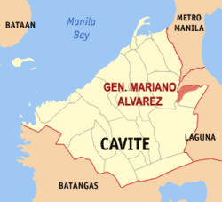
 Map of Cavite showing the location of Gen. Mariano Alvarez |
|||
| Coordinates: 14°18′N 121°00′E / 14.3°N 121°ECoordinates: 14°18′N 121°00′E / 14.3°N 121°E | |||
| Country | Philippines | ||
| Region | CALABARZON (Region IV-A) | ||
| Provinces | Cavite | ||
| Districts | 5th District of Cavite | ||
| Incorporated | March 14, 1981 | ||
| Barangays | 27 | ||
| Government | |||
| • Mayor | Walter Echevarria Jr. (LP) | ||
| • Vice Mayor | Maricel Torres (LP) | ||
| Area | |||
| • Total | 11.40 km2 (4.40 sq mi) | ||
| Population (2015 census) | |||
| • Total | 155,143 | ||
| • Rank | 12 out of 1,489 Municipalities | ||
| • Density | 14,000/km2 (35,000/sq mi) | ||
| Time zone | PST (UTC+8) | ||
| ZIP code | 4117 | ||
| IDD : area code | +63 (0)46 | ||
| Website | www |
||
General Mariano Alvarez (GMA; Filipino: Bayan ng Heneral Mariano Alvarez) is an urban municipality in the province of Cavite, Philippines. According to the 2015 census, it has a population of 155,143 people. With an area of just 11.40 square kilometers, it is the second most densely populated city/municipality in Cavite after Rosario.
The municipality was named after General Mariano Álvarez, a native of the town of Noveleta, Cavite.
General Mariano Alvarez, the super old town of the Province of Cavite, used to be a part of the Municipality of Carmona. This municipality was named after General Mariano Alvarez, one of the foremost sons of the province. He was a native of the town of Noveleta and he played a vital role during the Spanish Revolution. It had been called Carmona Resettlement Project and was under the direct management of the People’s Homesite and Housing Corporation (PHHC). This project started in March 1968 because of the need to clear the Quezon Memorial Park, Diliman, Quezon City of different shanties and other illegal constructions built on it. The PHHC prepared the basic development concepts with the National Planning Commission and the Department of Health comprising the Planning Group. The said group prescribed a minimum size of 12 x 12 or a total of 144 square meters for every family to be relocated in the area.
On July 3, 1968, the first seven families were admitted in the project. The Department of Social Welfare provided them with free three-day food rations for one month. During the same month, the Department of Health set up medical clinics with the Department of Education started holding classes on the Elementary and Second levels.
From 1970 to 1972, more families arrived in the area, including the flood victims and fire victims from the different parts of Quezon City, Makati and Manila. By the week of January 1073, the 7,80000 allocated lots were already filled up.
Since San Jose and San Gabriel were converted into resettlement areas, the said localities have been provided by the government with different infrastructure projects such as school buildings, health centers, road and bridges. The government, through the PHHC, allotted paces for commercial and industrial centers as well as civic and government centers.
...
Wikipedia


