Carmona, Cavite
| Carmona | ||
|---|---|---|
| Municipality | ||
| Municipality of Carmona | ||

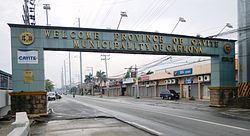
Carmona welcome sign
|
||
|
||
| Nickname(s): Center for Investment & Sports; Industrial Corridor of Cavite; Sorteo Capital of the Philippines | ||
| Motto: Bayan Muna Lagi (Town Always First) | ||
 Map of Cavite showing the location of Carmona |
||
| Location within the Philippines | ||
| Coordinates: 14°19′N 121°03′E / 14.32°N 121.05°ECoordinates: 14°19′N 121°03′E / 14.32°N 121.05°E | ||
| Country | Philippines | |
| Region | CALABARZON (Region IV-A) | |
| Province | Cavite | |
| District | 5th District of Cavite | |
| Founded | 16th century | |
| Incorporated | February 20, 1857 | |
| Barangays | 14 | |
| Government | ||
| • Type | Sangguniang Bayan | |
| • Mayor | Dahlia A. Loyola (LP) | |
| • Vice Mayor | Elmer M. Reyez (LP) | |
| • Town Council | ||
| Area | ||
| • Total | 40.24 km2 (15.54 sq mi) | |
| • Land | 30.92 km2 (11.94 sq mi) | |
| Highest elevation | 87 m (285 ft) | |
| Lowest elevation | 38 m (125 ft) | |
| Population (2015 census) | ||
| • Total | 97,557 | |
| • Density | 2,203/km2 (5,710/sq mi) | |
| Demonym(s) | Taga-Carmona | |
| Time zone | PST (UTC+8) | |
| ZIP code | 4116 | |
| IDD : area code | +63 (0)46 | |
| Languages | Tagalog, Chavacano, and English | |
| Income class | 1st Class | |
| Website | carmonagov |
|
Carmona (Filipino: Bayan ng Carmona) is a first class urban municipality in the province of Cavite, Philippines. According to the 2015 census, it has a population of 97,557 people.
Carmona is located on the south-eastern part of the province of Cavite, approximately 36 kilometres (22 mi) south of Manila and 24 kilometres (15 mi) from Trece Martires City, Cavite’s provincial capital. It is bounded on the north, east and south by the City of Biñan, Laguna, Municipality of General Mariano Alvarez (GMA) on the north-west and Silang on the south-west. The geographic coordinates of Carmona are about 14.32° latitude and 121.06° longitude.
With a total land area of 3,092 hectares or 30.92 square kilometers, Carmona represented 2.17% of the total land area of the province. These areas are currently occupied by 14 barangays of which 7 are considered Poblacion barangays and 7 others are regular barangays. Barangay Lantic is the largest area while Barangay 2 has the smallest area.
The topography of Carmona is generally flat to strongly rolling or sloping, partly lowland and partly hill. Carmona is divided into four physiographical areas: the lowest lowland area, the lowland area, the central hilly area and the upland mountainous area.
The first slope of the municipality is 0-3%; broad to level or nearly level is classified as under 0-3% slope. This is generally the flat plain level lands of the Barangay Maduya.
The second slope, ranging from 3 to 8%, is gently sloping areas with land sloping, gently undulating and rolling. This area comprises Poblacion 1 through 8, and also a portion of Cabilang Baybay with a small portion of Barangays Milagrosa and Mabuhay.
In the central area of the municipality is a slope ranging from 8 to 18%. This area comprises the rest of Barangay Milagrosa, a small portion of Barangay Cabilang Baybay and the middle portion of Barangay Mabuhay and Lantic.
...
Wikipedia


