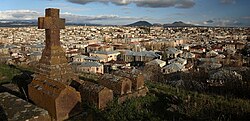
Gavar
|
Gavar Գավառ Kyavar (Քյավառ) |
||
|---|---|---|

Gavar
|
||
|
||
| Coordinates: 40°21′32″N 45°07′36″E / 40.35889°N 45.12667°E | ||
| Country |
|
|
| Marz | Gegharkunik | |
| Founded City status |
1830 1850 |
|
| Government | ||
| • Mayor | Gurgen Martirosyan | |
| Area | ||
| • Total | 16 km2 (6 sq mi) | |
| Elevation | 1,982 m (6,503 ft) | |
| Population (2011 census) | ||
| • Total | 20,765 | |
| • Density | 1,300/km2 (3,400/sq mi) | |
| Time zone | AMT (UTC+4) | |
| Postal code | 1201-1205 | |
| Area code(s) | (+374) 264 | |
| Vehicle registration | 02 | |
| Website | Official website | |
| Sources: Population | ||
Coordinates: 40°21′32″N 45°07′36″E / 40.35889°N 45.12667°E
Gavar (Armenian: Գավառ), is a town in Armenia and the capital of the Gegharkunik Province. It is situated among the high mountains of Gegham range to the west of Lake Sevan, with an average height of 1982 meters above sea level. Located 98 kilometers east of the capital Yerevan, the town had a population of 20,765 as per the 2011 census. As of the 2016 official estimate, the population of Gavar is 19,500.
The town was known as Nor Bayezet or Novo-Bayazet until 1959, named after the Western Armenian town of Bayazet (historically known as Daroynk and Arshakavan). Between 1959 and 1995, the town was known as Kamo, named after the Bolshevik revolutionary Kamo (Simon Ter-Petrosian). On December 4, 1995, the town was renamed Gavar, meaning county in the Armenian language.
However, Gavar is colloquially known as Kyavar (Քյավառ) since the 19th century.
Gavar was founded as Novo-Bayazet (New Bayazit) in 1830 around 8 km west of the Lake Sevan, by Armenian migrants from the town of Bayazit (historically known as Daroynk and Arshakavan) of the Ottoman Empire. The settlement achieved the status of a town in 1850.
...
Wikipedia


