Gau-Odernheim
| Gau-Odernheim | ||
|---|---|---|
|
||
| Coordinates: 49°47′5″N 8°11′39″E / 49.78472°N 8.19417°ECoordinates: 49°47′5″N 8°11′39″E / 49.78472°N 8.19417°E | ||
| Country | Germany | |
| State | Rhineland-Palatinate | |
| District | Alzey-Worms | |
| Municipal assoc. | Alzey-Land | |
| Government | ||
| • Mayor | Heiner Illing (SPD) | |
| Area | ||
| • Total | 18.27 km2 (7.05 sq mi) | |
| Population (2015-12-31) | ||
| • Total | 3,823 | |
| • Density | 210/km2 (540/sq mi) | |
| Time zone | CET/CEST (UTC+1/+2) | |
| Postal codes | 55239 | |
| Dialling codes | 06733 | |
| Vehicle registration | AZ | |
| Website | www.gau-odernheim.de | |
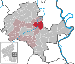
Gau-Odernheim (until 1896 simply Odernheim) is an Ortsgemeinde – a municipality belonging to a Verbandsgemeinde, a kind of collective municipality – in the Alzey-Worms district in Rhineland-Palatinate, Germany.
The municipality lies in Rhenish Hesse and belongs to the Verbandsgemeinde of Alzey-Land, whose seat is in Alzey.
Gau-Odernheim lies on the little river Selz, which snakes its way along the Petersberg (mountain). The nearest towns are Alzey (8 km) with both the district and Verbandsgemeinde seats, and Wörrstadt (12 km). The state capital Mainz, 30 km away, can be reached easily on the Autobahn A 63. As a winegrowing centre, Gau-Odernheim lies in Germany’s biggest winegrowing district and in the middle of the Rheinhessen (Rhenish Hesse) wine region. Because it is near the Frankfurt Rhine Main Region, the municipality is also a bedroom community and therefore has many new development areas and new citizens.
Gau-Odernheim’s neighbours are Bechtolsheim, Biebelnheim, Framersheim, Hillesheim and Dittelsheim-Heßloch.
Gau-Odernheim has a main centre with the outlying centre (Ortsteil) of Gau-Köngernheim
...
Wikipedia


