Gateway, Arkansas
| Gateway, Arkansas | |
|---|---|
| Town | |

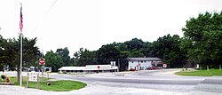
Principal intersection in Gateway, Arkansas
|
|
 Location in Benton County and the state of Arkansas |
|
| Coordinates: 36°29′10″N 93°56′18″W / 36.48611°N 93.93833°WCoordinates: 36°29′10″N 93°56′18″W / 36.48611°N 93.93833°W | |
| Country | United States |
| State | Arkansas |
| County | Benton |
| Area | |
| • Total | 6.1 sq mi (15.9 km2) |
| • Land | 6.1 sq mi (15.9 km2) |
| • Water | 0 sq mi (0 km2) |
| Elevation | 1,535 ft (468 m) |
| Population (2010) | |
| • Total | 405 |
| • Density | 66/sq mi (25.5/km2) |
| Time zone | Central (CST) (UTC-6) |
| • Summer (DST) | CDT (UTC-5) |
| ZIP code | 72733 |
| Area code(s) | 479 |
| FIPS code | 05-26110 |
| GNIS feature ID | 0057802 |
Gateway is a town in Benton County, Arkansas, United States. The population was 405 at the 2010 census, up from 116 at the 2000 census. It is part of the Fayetteville–Springdale–Rogers, AR-MO Metropolitan Statistical Area. The town's name reflects its situation as the "gateway" to and from Arkansas.
Gateway is located in northeastern Benton County at 36°29′10″N 93°56′18″W / 36.48611°N 93.93833°W (36.486000, -93.938253), along the Missouri border. U.S. Route 62 passes through the town, leading east to Eureka Springs and Berryville and southwest to Rogers. Arkansas Highway 37 leads north to the Missouri line, where Missouri Route 37 continues north to Seligman and Cassville, Missouri. Gateway is on a plateau in the Ozarks at 1,600 feet (490 m) above sea level, overlooking the valley of the White River and Beaver Lake to the south.
...
Wikipedia
