Gassin
| Gassin | ||
|---|---|---|

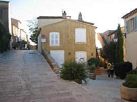
A view within the village of Gassin
|
||
|
||
| Coordinates: 43°13′47″N 6°35′09″E / 43.2297°N 6.5858°ECoordinates: 43°13′47″N 6°35′09″E / 43.2297°N 6.5858°E | ||
| Country | France | |
| Region | Provence-Alpes-Côte d'Azur | |
| Department | Var | |
| Arrondissement | Draguignan | |
| Canton | Saint-Tropez | |
| Government | ||
| • Mayor | Anne-Marie Waniart | |
| Area1 | 24.74 km2 (9.55 sq mi) | |
| Population (2006)2 | 2,912 | |
| • Density | 120/km2 (300/sq mi) | |
| Time zone | CET (UTC+1) | |
| • Summer (DST) | CEST (UTC+2) | |
| INSEE/Postal code | 83065 /83580 | |
| Elevation | 0–324 m (0–1,063 ft) | |
|
1 French Land Register data, which excludes lakes, ponds, glaciers > 1 km² (0.386 sq mi or 247 acres) and river estuaries. 2Population without double counting: residents of multiple communes (e.g., students and military personnel) only counted once. |
||
1 French Land Register data, which excludes lakes, ponds, glaciers > 1 km² (0.386 sq mi or 247 acres) and river estuaries.
Gassin is a commune in the Var department in the Provence-Alpes-Côte d'Azur region in southeastern France.
It is located very near to the holiday destination of Saint-Tropez. Perched high up on a rock, it is less than 4 km (2.5 mi) from the sea. Many Tropezian tourists attracted by a more affordable life prefer to stay in Gassin and enjoy the same kind of "Cote d'Azur" life.
It lies 2 kilometres from route D559 which links Hyères (41 km) and Sainte-Maxime (12 km).
...
Wikipedia


