Garwood, New Jersey
| Garwood, New Jersey | |
|---|---|
| Borough | |
| Borough of Garwood | |

A foggy morning
|
|
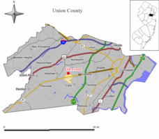
 Map of Garwood in Union County. Inset: Location of Union County in the State of New Jersey. |
|
 Census Bureau map of Garwood, New Jersey |
|
| Coordinates: 40°39′04″N 74°19′23″W / 40.651249°N 74.323137°WCoordinates: 40°39′04″N 74°19′23″W / 40.651249°N 74.323137°W | |
| Country | |
| State |
|
| County | Union |
| Incorporated | March 19, 1903 |
| Government | |
| • Type | Borough |
| • Body | Borough Council |
| • Mayor | Charles P. Lombardo (D, term ends December 31, 2018) |
| • Administrator / Clerk | Christina M. Ariemma |
| Area | |
| • Total | 0.664 sq mi (1.720 km2) |
| • Land | 0.664 sq mi (1.720 km2) |
| • Water | 0.000 sq mi (0.000 km2) 0.00% |
| Area rank | 533rd of 566 in state 20th of 21 in county |
| Elevation | 82 ft (25 m) |
| Population (2010 Census) | |
| • Total | 4,226 |
| • Estimate (2015) | 4,351 |
| • Rank | 404th of 566 in state 20th of 21 in county |
| • Density | 6,362.7/sq mi (2,456.7/km2) |
| • Density rank | 76th of 566 in state 8th of 21 in county |
| Time zone | Eastern (EST) (UTC-5) |
| • Summer (DST) | Eastern (EDT) (UTC-4) |
| ZIP code | 07027 |
| Area code(s) | 908 |
| FIPS code | 3403925800 |
| GNIS feature ID | 0885229 |
| Website | www |
Garwood is a borough in Union County, New Jersey, United States. As of the 2010 United States Census, the borough's population was 4,226, reflecting an increase of 73 (+1.8%) from the 4,153 counted in the 2000 Census, which had in turn declined by 74 (-1.8%) from the 4,227 counted in the 1990 Census.
Garwood was incorporated as a borough on March 19, 1903, from portions of Cranford Township and Westfield Town.
According to the United States Census Bureau, the borough had a total area of 0.664 square miles (1.720 km2), all of which was land.
The borough is roughly bisected by the tracks of NJ Transit's Raritan Valley Line, originally built as part of the Jersey Central railroad. On the north side of the railroad, most of the streets are numbered, while on the south side of Garwood most of the streets are named after trees.
Garwood borders the Union County municipalities of Cranford and Westfield.
As of the 2010 United States Census, there were 4,226 people, 1,778 households, and 1,118 families residing in the borough. The population density was 6,362.7 per square mile (2,456.7/km2). There were 1,870 housing units at an average density of 2,815.5 per square mile (1,087.1/km2). The racial makeup of the borough was 93.23% (3,940) White, 1.06% (45) Black or African American, 0.02% (1) Native American, 2.04% (86) Asian, 0.00% (0) Pacific Islander, 1.80% (76) from other races, and 1.85% (78) from two or more races. Hispanic or Latino of any race were 8.83% (373) of the population.
...
Wikipedia
