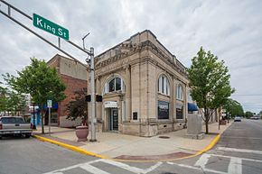
Garrett, Indiana
| Garrett, Indiana | |
|---|---|
| City | |
 |
|
 Location in the state of Indiana |
|
| Coordinates: 41°20′52″N 85°08′01″W / 41.34778°N 85.13361°WCoordinates: 41°20′52″N 85°08′01″W / 41.34778°N 85.13361°W | |
| Country | United States |
| State | Indiana |
| County | DeKalb |
| Township | Keyser |
| Government | |
| • Mayor | Todd Fiandt (D) |
| Area | |
| • Total | 3.85 sq mi (9.97 km2) |
| • Land | 3.85 sq mi (9.97 km2) |
| • Water | 0 sq mi (0 km2) |
| Elevation | 879 ft (268 m) |
| Population (2010) | |
| • Total | 6,286 |
| • Estimate (2012) | 6,291 |
| • Density | 1,632.7/sq mi (630.4/km2) |
| Time zone | EST (UTC-5) |
| • Summer (DST) | EDT (UTC-4) |
| ZIP code | 46738 |
| Area code(s) | 260 |
| FIPS code | 18-26386 |
| GNIS feature ID | 0434969 |
| Website | http://www.garrettindiana.us |
Garrett is a city in Keyser Township, DeKalb County, Indiana, United States. The population was 6,286 at the 2010 census.
Garrett was platted in 1875 when the Baltimore and Ohio Railroad was extended to that point. It was named for John W. Garrett (1820–1884), president of the Baltimore and Ohio Railroad from 1858 to 1884. Garrett was incorporated as a city in 1875.
Garrett is located at 41°20′52″N 85°8′1″W / 41.34778°N 85.13361°W (41.347903, -85.133700).
According to the 2010 census, Garrett has a total area of 3.85 square miles (9.97 km2), all land.
Garrett sits just west of Auburn, a larger town and county seat of DeKalb County. Both Garrett and Auburn are about 15 miles north of Fort Wayne.
As of the 2010 United States Census, there were 6,286 people in the city of Garrett, Indiana. The city grew 8.32% since the 2000 United States Census.
The city was 47.95% male (3,014) and 52.05% female (3,272).
The racial makeup of the city was:
The age of the population was:
As of the census of 2000, there were 5,803 people, 2,185 households, and 1,516 families residing in the city. The population density was 1,856.5 people per square mile (715.8/km²). There were 2,364 housing units at an average density of 756.3 per square mile (291.6/km²). The racial makeup of the city was 97.47% White, 0.29% African American, 0.33% Native American, 0.50% Asian, 0.16% Pacific Islander, 0.62% from other races, and 0.64% from two or more races. Hispanic or Latino of any race were 2.07% of the population.
...
Wikipedia
