Garfield, Victoria
|
Garfield Victoria |
|||||||||||||
|---|---|---|---|---|---|---|---|---|---|---|---|---|---|

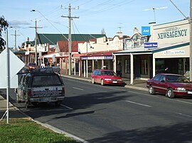
Main street
|
|||||||||||||
| Coordinates | 38°04′S 145°41′E / 38.067°S 145.683°ECoordinates: 38°04′S 145°41′E / 38.067°S 145.683°E | ||||||||||||
| Population | 1,466 (2011 census) | ||||||||||||
| Postcode(s) | 3814 | ||||||||||||
| Location | |||||||||||||
| LGA(s) | Shire of Cardinia | ||||||||||||
| State electorate(s) | Narracan | ||||||||||||
| Federal Division(s) | McMillan | ||||||||||||
|
|||||||||||||
Garfield is a town in Gippsland, Victoria, Australia, 69 km south-east of the Melbourne central business district. Its local government area is the Shire of Cardinia. At the 2011 Census, Garfield had a population of 1,466.
The area was originally called Cannibal Creek, but was renamed to Garfield in memory of the USA President James Garfield.
The Post Office opened as Cannibal Creek on 1 May 1886 and was renamed Garfield in 1887.
In the late 1980s the appearance of the town was transformed for the cameras to look like the 1960s in a television miniseries on aboriginal boxer, Lionel Rose, who was raised in the region in Jacksons Track, near Drouin. Some shop fronts were restored and the main street of the town was filled with old cars to recreate the era.
Since the beginnings as a railway and timber town, and later a dairy and potato farming and orchard area, Garfield has always been a close community, with almost everybody knowing everyone else, and in some cases four generations of family staying in the (mainly), farming area. Recent growth has seen a doubling of residential building and the (2006), upgrading of the railway line from Melbourne to Traralgon with increases in frequency of services by upgraded modern trains, is an attraction to new residents. A housing development, nearing completion in 2007, is for over-55s in a secure environment. Previously derelict shops on the main street are now reoccupied.
...
Wikipedia

