Garanhuns
| Garanhuns | |||
|---|---|---|---|
| Municipality | |||
|
Município de Garanhuns Municipality of Garanhuns |
|||

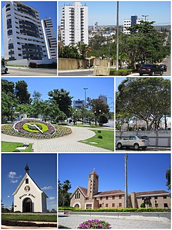
Top left: Heliopolis area
Top right: Gonçalves Maia Street Middle left: Floral Clock (Relógio das Flores) Middle right: Dom Moura Square Bottom left: Mãe Rainha Sanctuary Bottom right: Saint Joseph Seminary (Seminário São José) |
|||
|
|||
|
Nickname(s): "Suíça pernambucana" ("Switzerland in Pernambuco"), "Cidade das flores" ("City of Flowers") |
|||
 |
|||
| Location in Brazil | |||
| Coordinates: 08°53′25″S 36°29′34″W / 8.89028°S 36.49278°WCoordinates: 08°53′25″S 36°29′34″W / 8.89028°S 36.49278°W | |||
| Country |
|
||
| Region | Northeast | ||
| State |
|
||
| Founded | 1879 | ||
| Government | |||
| • Mayor | Izaías Régis Neto {PTB} | ||
| Area | |||
| • Total | 472.462 km2 (182.419 sq mi) | ||
| Elevation | 896 m (2,940 ft) | ||
| Population (2011) | |||
| • Total | 130.303 | ||
| • Density | 275.8/km2 (714/sq mi) | ||
| Demonym(s) | garanhuense | ||
| Time zone | BRT (UTC−3) | ||
| • Summer (DST) | BRST (UTC−2) | ||
| Garanhuns | ||||||||||||||||||||||||||||||||||||||||||||||||||||||||||||
|---|---|---|---|---|---|---|---|---|---|---|---|---|---|---|---|---|---|---|---|---|---|---|---|---|---|---|---|---|---|---|---|---|---|---|---|---|---|---|---|---|---|---|---|---|---|---|---|---|---|---|---|---|---|---|---|---|---|---|---|---|
| Climate chart () | ||||||||||||||||||||||||||||||||||||||||||||||||||||||||||||
|
||||||||||||||||||||||||||||||||||||||||||||||||||||||||||||
|
||||||||||||||||||||||||||||||||||||||||||||||||||||||||||||
| J | F | M | A | M | J | J | A | S | O | N | D |
|
46
27
17
|
58
27
17
|
99
27
18
|
114
24
16
|
104
24
17
|
122
23
17
|
132
21
16
|
74
23
16
|
48
23
15
|
33
27
17
|
18
29
17
|
23
28
17
|
| Average max. and min. temperatures in °C | |||||||||||
| Precipitation totals in mm | |||||||||||
| Source: The Weather Channel (in Portuguese) | |||||||||||
| Imperial conversion | |||||||||||
|---|---|---|---|---|---|---|---|---|---|---|---|
| J | F | M | A | M | J | J | A | S | O | N | D |
|
1.8
81
63
|
2.3
81
63
|
3.9
81
64
|
4.5
75
61
|
4.1
75
63
|
4.8
73
63
|
5.2
70
61
|
2.9
...
| ||||


