Gande (river)
| Gande | |
|---|---|

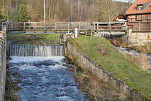
The Gande in Bad Gandersheim.
|
|
| State | Lower Saxony, Germany |
| Basin features | |
| Main source | Near Lamspringe |
| River mouth | bei Kreiensen 51°51′15″N 9°56′57″E / 51.854038°N 9.949246°E |
| Progression | Leine → Aller → Weser → North Sea |
| River system | Weser |
| Landmarks | Small towns: Bad Gandersheim |
| Tributaries |
|
| Physical characteristics | |
| Discharge |
|
The Gande is a right-hand tributary of the River Leine in Lower Saxony.
It rises near the town of Lamspringe on the eastern side of the Sackwald in the county of Hildesheim and flows from there southwards between the Sackwald and the Heber ridges. It enter the district of Northeim near Altgandersheim. At Bad Gandersheim it turns west and empties into to the Leine at Kreiensen.
...
Wikipedia
