Sackwald
| Sackwald | |
|---|---|
| Highest point | |
| Peak | Ahrensberg |
| Elevation | 374 m (1,227 ft) |
| Geography | |
| Country | Germany |
| State | Lower Saxony |
| District | Hildesheim district |
| Range coordinates | 51°58′N 9°55′E / 51.97°N 9.92°ECoordinates: 51°58′N 9°55′E / 51.97°N 9.92°E |
| Parent range | Leine Uplands |
| Geology | |
| Age of rock | Cretaceous |
The Sackwald is a ridge, up to 374 m above sea level (NN) high, in the Lower Saxon Hills in the district of Hildesheim in the North German state of Lower Saxony. It is named after the village of Sack in the borough of Alfeld, the name meaning "Sack Forest".
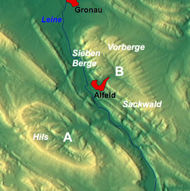
The Sackwald is part of the geological structure of the Sack Basin or Sackmulde along with the Sieben Berge and the Vorberge.
The Sackwald lies on the eastern edge of the Leine Uplands in the Lower Saxon Hills. It is located between the town of Alfeld on the River Leine to the northwest and the rather more distant town of Bad Gandersheim to the southeast.
The Sackwald is surrounded by the ridges of the Vorberge to the north, the southeastern foothills of the Hildesheim Forest to the north-northeast, the Sauberge to the northeast, the Harplage to the east-northeast, the Heber to the east, the Helleberg to the south and southwest, the Selter (on the other side of the Leine valley) to the southwest and the Sieben Berge to the northwest. Topographically it transitions into the last-named ridge seamlessly. Several streams rise within or on the edge of the Sackwald, whose waters eventually empty into the westward-running Leine or the northeast flowing Innerste; the ridge thus lies on the watershed between the two rivers.
...
Wikipedia

