Galion (OH)
| Galion, Ohio | |
|---|---|
| City | |

Saint Joseph Catholic Church located on North Liberty Street
|
|
 Location of Galion, Ohio |
|
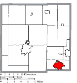
 Location of Galion in Crawford County |
|
| Coordinates: 40°43′59″N 82°47′19″W / 40.73306°N 82.78861°W | |
| Country | United States |
| State | Ohio |
| Counties | Crawford, Morrow, Richland |
| Government | |
| • Type | Mayor-Council |
| • Mayor | Mayor Tom O'Leary |
| Area | |
| • Total | 7.63 sq mi (19.76 km2) |
| • Land | 7.61 sq mi (19.71 km2) |
| • Water | 0.02 sq mi (0.05 km2) |
| Elevation | 1,171 ft (357 m) |
| Population (2010) | |
| • Total | 10,512 |
| • Estimate (2012) | 10,276 |
| • Density | 1,381.3/sq mi (533.3/km2) |
| Time zone | Eastern (EST) (UTC-5) |
| • Summer (DST) | EDT (UTC-4) |
| ZIP code | 44833 |
| Area code(s) | 419 |
| FIPS code | 39-29162 |
| GNIS feature ID | 1064699 |
| Website | http://www.galion.city |
Galion is a city in Crawford, Morrow, and Richland counties in the U.S. state of Ohio. The population was 10,512 at the 2010 census. Galion is the second-largest city in Crawford County after Bucyrus.
The Crawford County portion of Galion is part of the Bucyrus Micropolitan Statistical Area. The small portion of the city that is located in Richland County is part of the Mansfield Metropolitan Statistical Area, while the portion extending into Morrow County is considered part of the Columbus Metropolitan Statistical Area.
Galion was laid out in 1831. The etymology of the name Galion is uncertain. A post office called Galion has been in operation since 1825.
Galion is located in the southeastern corner of Crawford County at 40°43′59″N 82°47′19″W / 40.73306°N 82.78861°W (40.733164, -82.788586).
According to the United States Census Bureau, the city has a total area of 7.63 square miles (19.76 km2), of which 7.61 square miles (19.71 km2) is land and 0.02 square miles (0.05 km2) is water.
The Olentangy River begins near and runs through Galion, and then winds southward toward Columbus and eventually empties into the Scioto River.
...
Wikipedia
