Galena, Indiana
| Galena, Indiana | |
|---|---|
| Census-designated place | |
 |
|
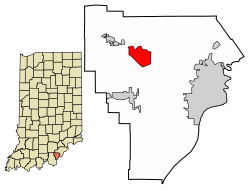
 Location of Galena in Floyd County, Indiana. |
|
| Coordinates: 38°21′2″N 85°56′26″W / 38.35056°N 85.94056°WCoordinates: 38°21′2″N 85°56′26″W / 38.35056°N 85.94056°W | |
| Country | United States |
| State | Indiana |
| County | Floyd |
| Area | |
| • Total | 2.68 sq mi (6.94 km2) |
| • Land | 2.67 sq mi (6.92 km2) |
| • Water | 0.01 sq mi (0.03 km2) |
| Elevation | 810 ft (247 m) |
| Population (2010) | |
| • Total | 1,818 |
| • Density | 680.9/sq mi (262.9/km2) |
| Time zone | Eastern (EST) (UTC-5) |
| • Summer (DST) | EDT (UTC-4) |
| ZIP code | 47119 |
| Area code(s) | 812 & 930 |
| FIPS code | 18-26206 |
| GNIS feature ID | 0434921 |
Galena is a census-designated place (CDP) in Floyd County, Indiana, United States. The population was 1,818 at the 2010 census. The CDP includes the town of Galena as well as the nearby town of Floyds Knobs and their immediate surroundings.
Galena was originally called Germantown, and under the latter name was platted in 1837. A post office was established as Galena in 1843, and remained in operation until it was discontinued in 1933.
Galena is located at 38°21′2″N 85°56′26″W / 38.35056°N 85.94056°W (38.350585, -85.940435).
According to the United States Census Bureau, the CDP has a total area of 2.68 square miles (6.94 km2), of which 2.67 square miles (6.92 km2) is land and 0.01 square miles (0.03 km2) is water.
As of the census of 2010, there were 1,818 people, 637 households, and 534 families residing in the CDP. The population density was 680.9 inhabitants per square mile (262.9/km2). There were 659 housing units at an average density of 246.8 per square mile (95.3/km2). The racial makeup of the CDP was 98.6% White, 0.2% Native American, 0.6% Asian, 0.1% from other races, and 0.6% from two or more races. Hispanic or Latino of any race were 0.7% of the population.
...
Wikipedia
