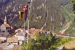
Göschenen
| Göschenen | ||
|---|---|---|
 |
||
|
||
| Coordinates: 46°40′N 8°35′E / 46.667°N 8.583°ECoordinates: 46°40′N 8°35′E / 46.667°N 8.583°E | ||
| Country | Switzerland | |
| Canton | Uri | |
| District | n.a. | |
| Area | ||
| • Total | 104.16 km2 (40.22 sq mi) | |
| Elevation | 1,111 m (3,645 ft) | |
| Population (Dec 2015) | ||
| • Total | 438 | |
| • Density | 4.2/km2 (11/sq mi) | |
| Postal code | 6487 | |
| SFOS number | 1208 | |
| Surrounded by | Andermatt, Gadmen (BE), Gurtnellen, Hospental, Oberwald (VS), Realp, Wassen | |
| Website |
www SFSO statistics |
|
Göschenen (German, Italian: Casinotta, Romansh: Caschanuttais) a village and municipality in the canton of Uri in Switzerland.
Göschenen is first mentioned in 1280 as Gesschenden. The name is from Rumantsch *cascina (modern caschigna) "alpine hut", from Latin capsum "corral", but influenced by the word for cheese, cascio. The e in the first syllable is due to Germanic i-umlaut, changed to ö in modern spelling is a hypercorrection based on the phonology of the dialect of Uri.
Göschenen has an area, as of 2006[update], of 104.1 km2 (40.2 sq mi). Of this area, 7.3% is used for agricultural purposes, while 11.4% is forested. Of the rest of the land, 0.9% is settled (buildings or roads) and the remainder (80.4%) is non-productive (rivers, glaciers or mountains). In the 1993/97 land survey[update], 5.1% of the total land area was heavily forested, while 5.5% is covered in small trees and shrubbery. Of the agricultural land, 0.0% is used for farming or pastures, while 0.7% is used for orchards or vine crops and 6.6% is used for alpine pastures. Of the settled areas, 0.1% is covered with buildings, 0.3% is classed as special developments, and 0.5% is transportation infrastructure. Of the unproductive areas, 1.3% is unproductive standing water (ponds or lakes), 0.9% is unproductive flowing water (rivers), 62.8% is too rocky for vegetation, and 15.4% is other unproductive land.
Göschenen and its railway station are located at the northern end of the Gotthard Road Tunnel and the Gotthard Rail Tunnel. The village grew up around a bridge over the Reuss. The Schöllenen Gorge in the Reuss Valley between Andermatt and Göschenen is the location of the infamous Devil's Bridge. A very short 1,000 mm (3 ft 3 3⁄8 in) metre gauge railway line, the Schöllenenbahn, connects Göschenen railway station with Andermatt railway station, via the Schöllenen Gorge.
...
Wikipedia


