Gödöllő
Gödöllő
|
||
|---|---|---|
| Town | ||

|
||
|
||
| Nickname(s): City of Sissi | ||
| Location of Gödöllő | ||
| Coordinates: 47°36′0.00″N 19°22′0.12″E / 47.6000000°N 19.3667000°ECoordinates: 47°36′0.00″N 19°22′0.12″E / 47.6000000°N 19.3667000°E | ||
| Country |
|
|
| Region | Central Hungary | |
| County | Pest | |
| Metro | Budapest metropolitan area | |
| Settled | 1349 | |
| Incorporated | 1868 | |
| Government | ||
| • Mayor | dr. György Gémesi | |
| • Town Notary | dr. Éva Nánási | |
| Area | ||
| • Town | 61.92 km2 (23.91 sq mi) | |
| • Land | 58.36 km2 (22.53 sq mi) | |
| • Water | 3.56 km2 (1.37 sq mi) | |
| Area rank | 97th in Hungary | |
| Elevation | 207 m (690 ft) | |
| Highest elevation | 317 m (1,040 ft) | |
| Lowest elevation | 189 m (620 ft) | |
| Population (1 January 2010) | ||
| • Town | 34 396 |
|
| • Rank | 29th | |
| • Density | 511.53/km2 (1,324.9/sq mi) | |
| • Urban | 104 471 | |
| • Demonym | gödöllői | |
| Population by ethnicity | ||
| • Hungarians | 94.4% | |
| • Gypsies | 1.1% | |
| • Germans | 0.6% | |
| • Slovaks | 0.4% | |
| • Ukrainians | 0.1% | |
| • Poles | 0.05% | |
| • Romanians | 0.04% | |
| Population by Religion | ||
| • Roman Catholics | 52.0% | |
| • Atheists | 15.3% | |
| • Calvinists | 14.8% | |
| • Lutherans | 3.1% | |
| • Greek Catholics | 1.2% | |
| Time zone | CET (UTC+1) | |
| • Summer (DST) | CEST (UTC+2) | |
| Postal Code | 2100 | |
| Area code(s) | 28 | |
| Motorways | M3 motorway (Hungary) M31 motorway (Hungary) | |
| Distance from Budapest | 30.7 km (19.1 mi) Southwest | |
| Website | www |
|
Gödöllő (Hungarian pronunciation: [ˈɡødølːøː]) (German: Getterle, Slovak: Jedľovo) is a town in Pest county, Budapest metropolitan area, Hungary, about 30 km (20 mi) northeast from the outskirts of Budapest. Its population is 34,396 according to the 2010 census and is growing rapidly. It can be easily reached from Budapest with the suburban railway (HÉV).
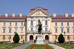
Gödöllő is home to the Szent István University, the main education institute of agriculture in Hungary. The palace at Gödöllő was originally built for the aristocratic Grassalkovich family; later Franz Josef, Emperor of Austria and King of Hungary and his wife Elisabeth ("Sisi") had their summer residence here.
Communism saw much of the town's original one-storey housing levelled to make way for the blocks of flats which continue to dominate the town centre, as well as much of the Royal Forest and Elisabeth's Park levelled for industrial use.
As far back as the Stone Age this area was populated.
The earliest evidence of occupation is from the Roman period. The Devil's Dykes (Hungarian: Ördögárok) is situated south from Gödöllő. It is also known as the Csörsz árka ("Csörsz Ditch") or the Limes Sarmatiae (Latin for "Sarmatian border"), are several lines of Roman fortifications built mostly during the reign of Constantine I (312–337).
The earliest available written data on the property rights in Gödöllő date from the early 14th century. At that time Gödöllő was separated from the community of Besnyő which had a larger population. The settlement was then owned by families of the lesser nobility. By the middle of the 15th century Gödöllő developed into a village.
...
Wikipedia


