Fumay
| Fumay | ||
|---|---|---|
 |
||
|
||
| Coordinates: 49°59′39″N 4°42′27″E / 49.9942°N 4.7075°ECoordinates: 49°59′39″N 4°42′27″E / 49.9942°N 4.7075°E | ||
| Country | France | |
| Region | Grand Est | |
| Department | Ardennes | |
| Arrondissement | Charleville-Mézières | |
| Canton | Fumay | |
| Intercommunality | Ardennes Rives de Meuse | |
| Government | ||
| • Mayor (2008–2014) | Jean Blanchemanche | |
| Area1 | 37.56 km2 (14.50 sq mi) | |
| Population (2008)2 | 3,884 | |
| • Density | 100/km2 (270/sq mi) | |
| Time zone | CET (UTC+1) | |
| • Summer (DST) | CEST (UTC+2) | |
| INSEE/Postal code | 08185 / 08170 | |
| Elevation | 116–255 m (381–837 ft) (avg. 127 m or 417 ft) |
|
|
1 French Land Register data, which excludes lakes, ponds, glaciers > 1 km² (0.386 sq mi or 247 acres) and river estuaries. 2Population without double counting: residents of multiple communes (e.g., students and military personnel) only counted once. |
||
1 French Land Register data, which excludes lakes, ponds, glaciers > 1 km² (0.386 sq mi or 247 acres) and river estuaries.
Fumay (French pronunciation: [fy.mɛ]) is a commune in the Ardennes department in northern France, very close to the Belgian border. The engineer Charles-Hippolyte de Paravey was born in Fumay.
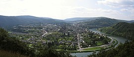
It is situated in the Meuse valley, the main part of the town being surrounded by a large meander of the river.
Fumay is sometimes known as "The City of Slate" (La Cité de l'Ardoise) due to the slate mining which brought prosperity to the town in the nineteenth century. The last slate mine was closed in 1971.
...
Wikipedia


