Fukang
|
Fukang 阜康市 • ﻓُﻮْﻛْﺎ شِ • فۇكاڭ شەھىرى (Chinese) • (Uyghur) • (Xiao'erjing) |
|
|---|---|
| County-level city | |

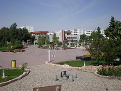
Central square in Fukang City
|
|
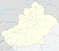
| Location in Xinjiang | |
| Coordinates: 44°08′N 87°56′E / 44.133°N 87.933°ECoordinates: 44°08′N 87°56′E / 44.133°N 87.933°E | |
| Country | China |
| Province | Xinjiang |
| Prefecture | Changji (Hui) |
| Township-level divisions | 3 Subdistricts 4 towns 1 townships 2 ethnic townships |
| Area | |
| • Total | 11,726 km2 (4,527 sq mi) |
| Population | |
| • Total | 1,500,000 |
| • Density | 130/km2 (330/sq mi) |
Fukang (Chinese: 阜康; pinyin: Fùkāng; Uyghur: فۇكاڭ, Фукаң) is a county-level city in Xinjiang Uygur Autonomous Region, China. Its area is 11726 km2. and its population in 2007 was reported as approximately 1.5 million. Fukang is located in northern Xinjiang in Changji Hui Autonomous Prefecture, north of Urumqi.
As early as the Han and Tang dynasties, Fukang was an important stopover on the ancient Silk Road. The Qianlong Emperor of the Qing dynasty established it as a county in 1776. Its status was changed to a city in November 1992.
In 2007, Fukang City's GDP was 4.822 billion yuan, 2.3 times that of 2002, an average annual increase of 17.6%. Per capita GDP reached 30,000 yuan, 2.1 times that of 2002, an average annual increase of 16.5%.
...
Wikipedia

