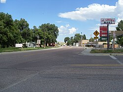
Ft. Laramie, Wyoming
| Fort Laramie, Wyoming | |
|---|---|
| Town | |

Main Street in Fort Laramie
|
|
 Location in Goshen County and the state of Wyoming |
|
| Location in the United States | |
| Coordinates: 42°12′48″N 104°31′2″W / 42.21333°N 104.51722°WCoordinates: 42°12′48″N 104°31′2″W / 42.21333°N 104.51722°W | |
| Country | United States |
| State | Wyoming |
| County | Goshen |
| Area | |
| • Total | 0.27 sq mi (0.70 km2) |
| • Land | 0.27 sq mi (0.70 km2) |
| • Water | 0 sq mi (0 km2) |
| Elevation | 4,239 ft (1,292 m) |
| Population (2010) | |
| • Total | 230 |
| • Estimate (2012) | 233 |
| • Density | 851.9/sq mi (328.9/km2) |
| Time zone | Mountain (MST) (UTC-7) |
| • Summer (DST) | MDT (UTC-6) |
| ZIP code | 82212 |
| Area code(s) | 307 |
| FIPS code | 56-28230 |
| GNIS feature ID | 1588642 |
Fort Laramie is a town in Goshen County, Wyoming, United States. The population was 230 at the 2010 census. The town is named after historic Fort Laramie, an important stop on the Oregon, California and Mormon trails, as well as a staging point for various military excursions and treaty signings. The old fort was located south of town across the North Platte River, at the mouth of the Laramie River.
In 1860 Fort Laramie served as a Pony Express station.
Fort Laramie is located at 42°12′48″N 104°31′2″W / 42.21333°N 104.51722°W (42.213233, -104.517123).
According to the United States Census Bureau, the town has a total area of 0.27 square miles (0.70 km2), all of it land.
As of the census of 2010, there were 230 people, 111 households, and 60 families residing in the town. The population density was 851.9 inhabitants per square mile (328.9/km2). There were 143 housing units at an average density of 529.6 per square mile (204.5/km2). The racial makeup of the town was 91.7% White, 1.3% Native American, 3.9% from other races, and 3.0% from two or more races. Hispanic or Latino of any race were 5.7% of the population.
...
Wikipedia

