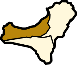
Frontera, Santa Cruz de Tenerife
| Frontera | |||
|---|---|---|---|
| Municipality | |||
|
|||
 |
|||
| Coordinates: 27°45′0″N 18°1′0″W / 27.75000°N 18.01667°WCoordinates: 27°45′0″N 18°1′0″W / 27.75000°N 18.01667°W | |||
| Country |
|
||
| Autonomous community |
|
||
| Province |
|
||
| Island |
|
||
| Area | |||
| • Total | 84.20 km2 (32.51 sq mi) | ||
| Elevation | 300 m (1,000 ft) | ||
| Population (2009) | |||
| • Total | 4,009 | ||
| • Density | 48/km2 (120/sq mi) | ||
| Postal code | E-38911 | ||
| Climate | BSh | ||
| Website | http://www.aytofrontera.org/ | ||
La Frontera (Spanish for "the border") is a municipality in the northwestern part of the island El Hierro, Santa Cruz de Tenerife, Canary Islands, Spain. In 2007, the southern part of the territory of La Frontera was split off to form the new municipality of El Pinar.
...
Wikipedia


