Frohna, Missouri
| Frohna, Missouri | |
|---|---|
| Village | |

Frohna, Missouri, road sign
|
|
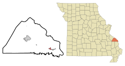
 Location of Frohna, Missouri |
|
| Coordinates: 37°38′26″N 89°37′9″W / 37.64056°N 89.61917°WCoordinates: 37°38′26″N 89°37′9″W / 37.64056°N 89.61917°W | |
| Country | United States |
| State | Missouri |
| County | Perry |
| Township | Brazeau |
| Area | |
| • Total | 0.90 sq mi (2.33 km2) |
| • Land | 0.90 sq mi (2.33 km2) |
| • Water | 0 sq mi (0 km2) |
| Elevation | 587 ft (179 m) |
| Population (2010) | |
| • Total | 254 |
| • Estimate (2012) | 257 |
| • Density | 282.2/sq mi (109.0/km2) |
| Time zone | Central (CST) (UTC-6) |
| • Summer (DST) | CDT (UTC-5) |
| ZIP code | 63748 |
| Area code(s) | 573 |
| FIPS code | 29-26092 |
| GNIS feature ID | 0736298 |
Frohna /ˈfroʊnə/ is a city in Perry County, Missouri, United States. The population was 254 at the 2010 census.
Frohna is named after the town of Niederfrohna (German: Lower Frohna) in the Zwickau district of the German region of Saxony. Although the German colony was initially called Niederfrohna, the Nieder- was eventually dropped from the name.
Frohna is one of seven towns and villages in the area founded by German immigrants in 1839. It and the others -- Altenburg, Dresden, Johannisberg, Paitzdorf, Seelitz, and Wittenberg—were all named by settlers for towns in the Saxony region of their native country.
Concordia Lutheran Church is a member of the Lutheran Church-Missouri Synod. The Saxon Fall Festival is held every October at the Saxon Lutheran Memorial.
The Saxon Lutheran Memorial is a tribute to the German Lutheran migration of 1838/1839, and features a number of log cabins from that era.
...
Wikipedia
