Altenburg, Missouri
| Altenburg, Missouri | |
|---|---|
| City | |
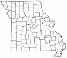
 Location of Altenburg, Missouri |
|
| Coordinates: 37°37′53″N 89°34′53″W / 37.63139°N 89.58139°WCoordinates: 37°37′53″N 89°34′53″W / 37.63139°N 89.58139°W | |
| Country | United States |
| State | Missouri |
| County | Perry |
| Township | Brazeau |
| Area | |
| • Total | 1.05 sq mi (2.72 km2) |
| • Land | 1.05 sq mi (2.72 km2) |
| • Water | 0 sq mi (0 km2) |
| Elevation | 584 ft (178 m) |
| Population (2010) | |
| • Total | 352 |
| • Estimate (2016) | 352 |
| • Density | 340/sq mi (130/km2) |
| Time zone | Central (CST) (UTC-6) |
| • Summer (DST) | CDT (UTC-5) |
| FIPS code | 29-00928 |
| GNIS feature ID | 0713250 |
Altenburg is a city in Perry County, Missouri, United States. The population was 352 at the 2010 census.
Altenburg (German for "Old Castle") was named after the Duchy of Saxe-Altenburg from where many of its settlers came, and not the city of Altenburg which does not seem to have sent a single colonist.
Altenburg was laid out and platted in 1839 by a colony of Lutherans.
Altenburg is one of seven towns and villages in the area founded by German Lutheran immigrants in 1839. It and the others—Dresden, Frohna, Johannisberg, Paitzdorf, Seelitz, and Wittenberg—were all named by settlers for towns in the Saxony region of their native country. These settlers would form the backbone of what would later become the Lutheran Church–Missouri Synod. Trinity Lutheran Church was established in 1839 in a log cabin, and was later replaced by a limestone, and then a frame church. Soon after arriving, the immigrants constructed a school in Altenburg. Made of native timber, this "Log Cabin College" introduced the new idea of a co-educational school, a rarity at the time. Today, Altenburg is home to the Lutheran Heritage Center and Museum, established in 1985. Tourists can explore several mid-19th century buildings that remain in the community as well as the Heritage Center's exhibition hall as well as the reading room and research library.
...
Wikipedia
