Frio River
| Frio River | |
|---|---|

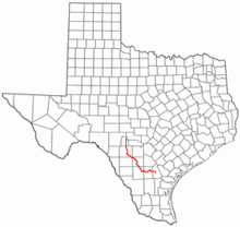
Location of the Frio River, Texas
|
|
| Country | United States |
| Basin features | |
| Main source |
Real County, Texas 2,300 ft (700 m) |
| River mouth | Nueces River, Live Oak County, Texas |
| Basin size | 7,310 sq mi (18,900 km2) |
| Physical characteristics | |
| Length | 200 mi (320 km) |
| Discharge |
|
The Frio River is a river in the U.S. state of Texas. The word frío is Spanish for cold, a clear reference to the spring-fed coolness of the river.
The Frio River has three primary tributaries; the East, West, and Dry Frio Rivers. The West Frio River rises from springs in northeastern Real County and joins with the East Frio River near the town of Leakey; the Dry Frio River joins northeast of Uvalde. The river flows generally southeast for 200 miles until it empties into the Nueces River south of the town of Three Rivers. Along the way, the Frio River provides water to the Choke Canyon Reservoir in McMullen and Live Oak Counties.
The cool and consistent flow of the Frio River has made it a popular summertime destination. Garner State Park, on the river about 10 miles (16 km) south of Leakey and 75 miles (121 km) west of San Antonio, provides camping, fishing and other activities. Numerous other privately owned campgrounds are also found along the river.
The Frio River flows through Garner State Park in Uvalde County, Texas.
Cypress trees line the waters of the Frio River, located in the Texas Hill Country.
The Frio River snakes through Garner State Park, located in Uvalde County, Texas, in the heart of the Texas Hill Country.
The Frio River winds along the east side of Garner State Park (on the left, showing a dam that forms a swimming area).
Coordinates: 28°26′15″N 98°11′19″W / 28.43750°N 98.18861°W
...
Wikipedia
