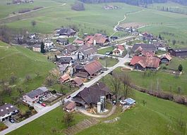
Freimettigen
| Freimettigen | |
|---|---|
 |
|
| Coordinates: 46°52′N 7°38′E / 46.867°N 7.633°ECoordinates: 46°52′N 7°38′E / 46.867°N 7.633°E | |
| Country | Switzerland |
| Canton | Bern |
| District | Bern-Mittelland |
| Area | |
| • Total | 2.95 km2 (1.14 sq mi) |
| Elevation | 675 m (2,215 ft) |
| Population (Dec 2015) | |
| • Total | 469 |
| • Density | 160/km2 (410/sq mi) |
| Postal code | 3510 |
| SFOS number | 0607 |
| Surrounded by | Häutligen, Konolfingen, Linden, Niederhünigen, Oberdiessbach |
| Website |
www SFSO statistics |
Freimettigen is a municipality in the Bern-Mittelland administrative district in the canton of Bern in Switzerland.
Freimettigen is first mentioned in 1282 as Vrimuotingen.
The oldest trace of a settlement in the area is a hoard of Bronze Age jewelry which was discovered in 1910. During the Middle Ages it was part of the Twingherrschaft of Hünigen. During the 13th and 14th centuries, Interlaken and Fraubrunnen Abbeys acquired bits of land in the village. These were probably taken by the city of Bern in 1528 when it secularized the Abbeys.
Freimettigen has always been part of the parish of Oberdiessbach.
The village has remained generally rural with a number of dairy farmers. The Burgdorf-Thun railway station provides transportation for workers who commute to Bern or Thun for jobs.
Freimettigen has an area of 2.95 km2 (1.14 sq mi). Of this area, 1.88 km2 (0.73 sq mi) or 63.7% is used for agricultural purposes, while 0.88 km2 (0.34 sq mi) or 29.8% is forested. Of the rest of the land, 0.17 km2 (0.066 sq mi) or 5.8% is settled (buildings or roads).
Of the built up area, housing and buildings made up 3.4% and transportation infrastructure made up 2.0%. Out of the forested land, all of the forested land area is covered with heavy forests. Of the agricultural land, 35.9% is used for growing crops and 26.4% is pastures, while 1.4% is used for orchards or vine crops.
The municipality is located on the north-west slope of the Kurzenberg, and a portion is in the Kiesen Valley. It includes the village of Freimettigen, the hamlet Dessikofen and scattered individual farm houses.
On 31 December 2009 Amtsbezirk Konolfingen, the municipality's former district, was dissolved. On the following day, 1 January 2010, it joined the newly created Verwaltungskreis Bern-Mittelland.
...
Wikipedia


