Freehold Township
| Freehold Township, New Jersey | ||
|---|---|---|
| Township | ||
| Township of Freehold | ||

Walker-Combs-Hartshorne Farmstead
|
||
|
||
| Motto: Western Monmouth's Family Town | ||
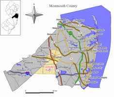
 Map of Freehold Township in Monmouth County. Inset: Location of Monmouth County highlighted in the State of New Jersey. |
||
 Census Bureau map of Freehold Township, New Jersey |
||
| Coordinates: 40°13′28″N 74°17′57″W / 40.224382°N 74.299051°WCoordinates: 40°13′28″N 74°17′57″W / 40.224382°N 74.299051°W | ||
| Country | ||
| State |
|
|
| County | Monmouth | |
| Established | October 31, 1693 | |
| Incorporated | February 21, 1798 | |
| Government | ||
| • Type | Township | |
| • Body | Township Committee | |
| • Mayor | Lester A. Preston Jr. (R, term ends December 31, 2017) | |
| • Administrator | Peter R. Valesi | |
| • Clerk | Terry Warner | |
| Area | ||
| • Total | 38.727 sq mi (100.303 km2) | |
| • Land | 38.503 sq mi (99.723 km2) | |
| • Water | 0.224 sq mi (0.580 km2) 0.58% | |
| Area rank | 59th of 566 in state 4th of 53 in county |
|
| Elevation | 118 ft (36 m) | |
| Population (2010 Census) | ||
| • Total | 36,184 | |
| • Estimate (2015) | 35,807 | |
| • Rank | 62nd of 566 in state 5th of 53 in county |
|
| • Density | 939.8/sq mi (362.9/km2) | |
| • Density rank | 393rd of 566 in state 45th of 53 in county |
|
| Time zone | Eastern (EST) (UTC-5) | |
| • Summer (DST) | Eastern (EDT) (UTC-4) | |
| ZIP code | 07728 | |
| Area code(s) | 732/848 and 908 (mobile) | |
| FIPS code | 3402525230 | |
| GNIS feature ID | 0882116 | |
| Website | twp |
|
Freehold Township is a township in Monmouth County, New Jersey, United States. As of the 2010 United States Census, the township's population was 36,184, reflecting an increase of 4,647 (+14.7%) from the 31,537 counted in the 2000 Census, which had in turn increased by 6,827 (+27.6%) from the 24,710 counted in the 1990 Census.
Freehold Township was first formed on October 31, 1693, and was incorporated as a township by an act of the New Jersey Legislature on February 21, 1798. Portions of Freehold Township were taken to form Upper Freehold Township (c. 1731), so some wills and official records following the split referred to "Lower Freehold Township" although the official name has always been Freehold Township. Additional portions formed Millstone Township (February 28, 1844), Jackson Township (March 6, 1844), Atlantic Township (February 18, 1847; now Colts Neck Township), Marlboro Township (February 17, 1848) and Manalapan Township (March 9, 1848). Freehold town was formed within the township on March 25, 1869, and formally separated when it was reconstituted as a borough on April 15, 1919, including additional portions of the township.
The Battle of Monmouth was fought in June 1778 in what has been preserved as Monmouth Battlefield State Park, which is in Freehold Township and Manalapan Township.
...
Wikipedia

