Marlboro Township, New Jersey
| Marlboro Township, New Jersey | ||
|---|---|---|
| Township | ||
| Township of Marlboro | ||
|
||
 Map of Marlboro Township in Monmouth County. Inset: Location of Monmouth County highlighted in the State of New Jersey. |
||
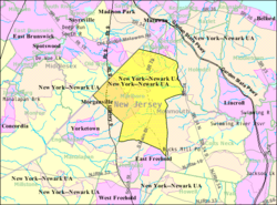
 Census Bureau map of Marlboro Township, New Jersey |
||
| Coordinates: 40°20′35″N 74°15′26″W / 40.342931°N 74.257197°WCoordinates: 40°20′35″N 74°15′26″W / 40.342931°N 74.257197°W | ||
| Country | ||
| State |
|
|
| County | Monmouth | |
| Incorporated | February 17, 1848 | |
| Named for | Marl beds | |
| Government | ||
| • Type | Faulkner Act (Mayor-Council) | |
| • Body | Township Council | |
| • Mayor | Jonathan L. Hornik (D, term ends December 31, 2019) | |
| • Administrator | Jonathan Capp | |
| • Clerk | Alida Manco | |
| Area | ||
| • Total | 30.471 sq mi (78.921 km2) | |
| • Land | 30.361 sq mi (78.636 km2) | |
| • Water | 0.110 sq mi (0.285 km2) 0.36% | |
| Area rank | 89th of 566 in state 9th of 53 in county |
|
| Elevation | 190 ft (60 m) | |
| Population (2010 Census) | ||
| • Total | 40,191 | |
| • Estimate (2015) | 40,671 | |
| • Rank | 53rd of 566 in state 3rd of 53 in county |
|
| • Density | 1,323.7/sq mi (511.1/km2) | |
| • Density rank | 352nd of 566 in state 42nd of 53 in county |
|
| Time zone | Eastern (EST) (UTC-5) | |
| • Summer (DST) | Eastern (EDT) (UTC-4) | |
| ZIP code | 07746 | |
| Area code(s) | 732/848 | |
| FIPS code | 3402544070 | |
| GNIS feature ID | 0882118 | |
| Website | www |
|
Marlboro Township is a township in Monmouth County, New Jersey, United States. As of the 2010 United States Census, the township had a population of 40,191, reflecting an increase of 5,449 (+16.3%) from the 33,423 counted in the 2000 Census, which had in turn increased by 6,707 (+25.1%) from the 26,716 counted in the 1990 Census.
Marlboro Township was formed by an act of the New Jersey Legislature on February 17, 1848, from portions of Freehold Township. The township was named for the marl beds found in the area.
While there is some debate on this, the Lenni Lenape Native Americans were the first known organized inhabitants of this area, having settled here about one thousand years ago and forming an agricultural society, occupying small villages that dotted what was to become Marlboro Township. Their villages were known to be in the Wickatunk and Crawford's Corner sections of the township.
In 1600, the Delaware / Lenape Native American population in the surrounding area may have numbered as many as 20,000. Several wars, at least 14 separate epidemics (yellow fever, small pox, influenza, encephalitis lethargica, etc.) and disastrous over-harvesting of the animal populations reduced their population to around 4,000 by the year 1700. Since the Lenape people, like all Native Americans, had no immunity to European diseases, when the populations contacted the epidemics, they frequently proved fatal. Some Lenape starved to death as a result of animal over-harvesting, while others were forced to trade their land for goods such as clothing and food. They were eventually moved to reservations set up by the US Government. They were first moved to the only Indian Reservation in New Jersey, the Brotherton Reservation in Burlington County, New Jersey (1758-1802). Those who remained survived through attempting to adapt to the dominant culture, becoming farmers and tradesmen. As the Lenni Lenape population declined, and the European population increased, the history of the area was increasingly defined by the new European inhabitants and the Lenape Native American tribes played an increasingly secondary role.
...
Wikipedia

