Freeborn County, Minnesota
| Freeborn County, Minnesota | |
|---|---|

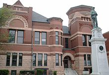
Freeborn County Courthouse
|
|
 Location in the U.S. state of Minnesota |
|
 Minnesota's location in the U.S. |
|
| Founded | February 20, 1855 |
| Named for | William Freeborn |
| Seat | Albert Lea |
| Largest city | Albert Lea |
| Area | |
| • Total | 722 sq mi (1,870 km2) |
| • Land | 707 sq mi (1,831 km2) |
| • Water | 15 sq mi (39 km2), 2.1% |
| Population (est.) | |
| • (2015) | 30,613 |
| • Density | 44/sq mi (17/km²) |
| Congressional district | 1st |
| Time zone | Central: UTC-6/-5 |
| Website | www |
Freeborn County is a county located in the State of Minnesota. As of the 2010 census, the population was 31,255. Its county seat is Albert Lea.
Freeborn County comprises the Albert Lea, MN Micropolitan Statistical Area.
Freeborn County was established in 1855. It is named for William Freeborn, an early Minnesota politician.
According to the U.S. Census Bureau, the county has a total area of 722 square miles (1,870 km2), of which 707 square miles (1,830 km2) is land and 15 square miles (39 km2) (2.1%) is water. The Le Sueur River, a tributary of the Minnesota River, begins in the northern part of the county.
Freeborn County has 16 lakes, mostly in the western half of the county.
As of the census of 2000, there were 32,584 people, 13,356 households, and 9,015 families residing in the county. The population density was 46 people per square mile (18/km²). There were 13,996 housing units at an average density of 20 per square mile (8/km²). The racial makeup of the county was 95.22% White, 0.24% Black or African American, 0.20% Native American, 0.55% Asian, 0.02% Pacific Islander, 2.92% from other races, and 0.85% from two or more races. 6.29% of the population were Hispanic or Latino of any race. 34.8% were of Norwegian, 26.2% German and 5.8% Danish ancestry.
...
Wikipedia
