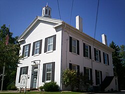
Franklin Township, Portage County, Ohio
| Franklin Township | |
|---|---|
| Civil township | |

Franklin Township Hall, built 1837
|
|
 Location in Portage County, Ohio |
|
| Location in the United States and Ohio | |
| Coordinates: 41°10′45″N 81°19′59″W / 41.17917°N 81.33306°W | |
| Country | United States |
| State | Ohio |
| County | Portage |
| Named | 1798 |
| Organized | 1802 |
| First election | 1815 |
| Founded by | Aaron Olmsted |
| Named for | Aaron Franklin Olmsted |
| Government | |
| • Type | Township trustees |
| • Trustees | Mark Beckwith Keith Benjamin Gary Falstad |
| Area | |
| • Total | 14.4 sq mi (37 km2) |
| • Land | 12.9 sq mi (33 km2) |
| • Water | 1.5 sq mi (4 km2) |
| Elevation | 1,102 ft (336 m) |
| Population (2010) | |
| • Total | 5,527 |
| • Density | 428.4/sq mi (165.4/km2) |
| Time zone | Eastern (EST) (UTC-5) |
| • Summer (DST) | EDT (UTC-4) |
| ZIP Codes | 44240, 44266 |
| Area code(s) | 330, 234 |
| FIPS code | 39-28392 |
| GNIS feature ID | 1086827 |
| Website | franklintownshipohio |
Franklin Township is a civil township located in Portage County, Ohio, United States. It is located along the Cuyahoga River in Northeast Ohio on the western edge of the county. The 2000 census found 5,276 people in the township and 5,527 at the 2010 Census. The township is part of the Akron Metropolitan Statistical Area and the larger Cleveland-Akron-Canton Combined Statistical Area.
Franklin Township was originally surveyed as Town 3 Range 9 as part of the Connecticut Western Reserve and was purchased by Aaron Olmsted in 1798. It was one of the first civil townships organized in the Western Reserve and initially covered a large area. The township was named by Aaron Olmsted after his son Aaron Franklin Olmsted. It was first settled in 1805 by John Haymaker and its government structure, which consists of three township trustees, was established in 1815. Today Franklin Township is a mostly rural area largely associated with the neighboring city of Kent as the two share a common history, public school district, ZIP code, and fire department.
The area that makes up Franklin Township was originally inhabited by a number of American Indian tribes including the Mound Builders who built a burial mound in the eastern part of the township sometime during the 1st century in what would become Towners Woods Park. Captain Samuel Brady crossed the area around 1780 as part of his campaigns against an unknown tribe, escaping by leaping the Cuyahoga River in present-day downtown Kent and hiding in Brady Lake. In 1796 the area was surveyed by the Connecticut Land Company as part of the Connecticut Western Reserve. The original survey township was known as Town 3 Range 9 and contained 25 square miles (65 km2) and 16,000 acres (6,500 ha) of land. Aaron Olmstead of East Hartford, Connecticut purchased this township at a cost of 12.5 cents an acre and named it for his son Aaron Franklin Olmstead. It is one of twenty-one . In 1802, much of the original Trumbull County, which covered the entire Western Reserve, was organized under the name of Franklin Township. The area under the Franklin Township name included all of present-day Portage County and much of present-day Summit County as well as parts of present-day Trumbull County. The following year, the township was surveyed into individual lots. At the formation of Portage County in 1807, Franklin Township included what would become Brimfield, Charlestown, Ravenna, and Rootstown townships.
...
Wikipedia


